IMAGES TAKEN NEAR TO
Laurel Crescent, CROYDON, CR0 8JP
Introduction
This page details the photographs taken nearby to Laurel Crescent, CR0 8JP by members of the Geograph project.
The Geograph project started in 2005 with the aim of publishing, organising and preserving representative images for every square kilometre of Great Britain, Ireland and the Isle of Man.

There are currently over 7.5m images from over14,400 individuals and you can help contribute to the project by visiting https://www.geograph.org.uk
Image Map
Images are licensed for reuse under creativecommons.org/licenses/by-sa/2.0
Notes
- Clicking on the map will re-center to the selected point.
- The higher the marker number, the further away the image location is from the centre of the postcode.
Image Listing (48 Images Found)
Images are licensed for reuse under creativecommons.org/licenses/by-sa/2.0
Image
Details
Distance
2
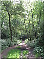
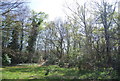
Footpath in the wood east of Border Gardens, CR0 (2)
Image: © Mike Quinn
Taken: 16 Jun 2010
0.11 miles
3
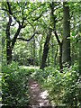
Footpath in the wood east of Border Gardens, CR0
Image: © Mike Quinn
Taken: 16 Jun 2010
0.12 miles
4
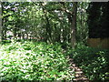
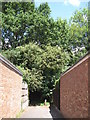
Footpath in the wood west of Briar Lane, CR0
Image: © Mike Quinn
Taken: 16 Jun 2010
0.13 miles
5
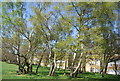
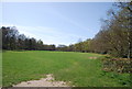
Clump of trees, Shirley Heath Recreation Ground
Image: © N Chadwick
Taken: 9 Apr 2011
0.14 miles
6
Footpath into the wood north of Briar Lane, CR0
Image: © Mike Quinn
Taken: 16 Jun 2010
0.15 miles
7
Woodland by Shirley Heath Recreation Ground
Image: © N Chadwick
Taken: 9 Apr 2011
0.16 miles
8
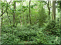
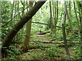
The northern finger of Threehalfpenny Wood
This runs north for some way, but the paths (if you can call them that) are lightly used.
Image: © Robin Webster
Taken: 1 Jul 2011
0.16 miles
10
The northern finger of Threehalfpenny Wood
This runs north for some way, but the paths are lightly used.
Image: © Robin Webster
Taken: 1 Jul 2011
0.18 miles