IMAGES TAKEN NEAR TO
Bennetts Way, CROYDON, CR0 8AD
Introduction
This page details the photographs taken nearby to Bennetts Way, CR0 8AD by members of the Geograph project.
The Geograph project started in 2005 with the aim of publishing, organising and preserving representative images for every square kilometre of Great Britain, Ireland and the Isle of Man.

There are currently over 7.5m images from over14,400 individuals and you can help contribute to the project by visiting https://www.geograph.org.uk
Image Map
Images are licensed for reuse under creativecommons.org/licenses/by-sa/2.0
Notes
- Clicking on the map will re-center to the selected point.
- The higher the marker number, the further away the image location is from the centre of the postcode.
Image Listing (67 Images Found)
Images are licensed for reuse under creativecommons.org/licenses/by-sa/2.0
Image
Details
Distance
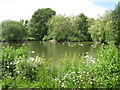
2
Millers Pond
A small park whose principal feature is a pond, but there is also a patch of grass. The pond is to the right - note the Moorhen going on an overland adventure.
Image: © Robin Webster
Taken: 1 Jul 2011
0.06 miles


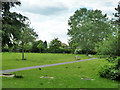
5

Millers Pond
In a small park also called Millers Pond. The most numerous water fowl were Canada Geese.
Image: © Robin Webster
Taken: 1 Jul 2011
0.08 miles
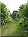
6

Millers Pond
Water flows northwards out of this pond and (presumably) into either the Chaffinch Brook in Image or Image - see the satellite image http://wtp2.appspot.com/wheresthepath.htm?lat=51.376830111062446&lon=-0.030405521392822265&gz=16&oz=9>=1.
Image: © Mike Quinn
Taken: 16 Jun 2010
0.08 miles
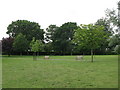
8
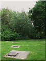
Drain covers marking a feed into Millers Pond
These drain covers can be seen on the satellite image http://wtp2.appspot.com/wheresthepath.htm?lat=51.373051969661304&lon=-0.03471282613276194&gz=20&oz=10>=1. Scary.
Image: © Mike Quinn
Taken: 16 Jun 2010
0.08 miles