IMAGES TAKEN NEAR TO
Longheath Gardens, CROYDON, CR0 7TW
Introduction
This page details the photographs taken nearby to Longheath Gardens, CR0 7TW by members of the Geograph project.
The Geograph project started in 2005 with the aim of publishing, organising and preserving representative images for every square kilometre of Great Britain, Ireland and the Isle of Man.

There are currently over 7.5m images from over14,400 individuals and you can help contribute to the project by visiting https://www.geograph.org.uk
Image Map
Images are licensed for reuse under creativecommons.org/licenses/by-sa/2.0
Notes
- Clicking on the map will re-center to the selected point.
- The higher the marker number, the further away the image location is from the centre of the postcode.
Image Listing (74 Images Found)
Images are licensed for reuse under creativecommons.org/licenses/by-sa/2.0
Image
Details
Distance

7
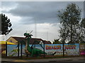
Long Lane Dragon
The owners of the Image have used a corner of their site for a dungeons and dragons themed crazy golf course. This splendid dragon has appeared recently to advertise the attraction. The nets surrounding the driving range are visible in the background. See also Image
Image: © Roger W Haworth
Taken: 13 Oct 2012
0.14 miles
8
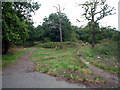
Long Lane Woods, Croydon
15 acres of rat-infested and litter-strewn woodland beside Long Lane, open all the time to the public. It was shown on Thomas Bainbridges map of Croydon in 1800. The area has remained almost unaltered - litter louts, lovers and lurkers excepted - but surrounding fields have been replaced by houses and gardens.
Image: © Philip Talmage
Taken: 6 Aug 2005
0.15 miles
9
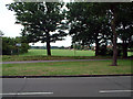
Ashburton Playing Fields, Croydon, from the north
In Monks Orchard, these playing fields, totalling 50 acres, run from Bywood Avenue in the north to Chaucer Green in the west and Woodville Avenue in the east, the houses in Stroud Green Way back onto the western boundary. The Chaffinch Brook runs north through the Playing Fields. Another view, from the south, is in TQ3566.
Image: © Philip Talmage
Taken: 6 Aug 2005
0.15 miles
10
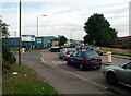
Entrance to Croydon Road Industrial Estate, Elmers End, Beckenham; BR3 4BY
Just inside the boundary with Croydon LB, this industrial estate, to the left of the picture, occupies an area bounded by railway lines. The road that passes by is the A222.
Image: © Philip Talmage
Taken: 6 Aug 2005
0.15 miles