IMAGES TAKEN NEAR TO
Woodmere Avenue, CROYDON, CR0 7PF
Introduction
This page details the photographs taken nearby to Woodmere Avenue, CR0 7PF by members of the Geograph project.
The Geograph project started in 2005 with the aim of publishing, organising and preserving representative images for every square kilometre of Great Britain, Ireland and the Isle of Man.

There are currently over 7.5m images from over14,400 individuals and you can help contribute to the project by visiting https://www.geograph.org.uk
Image Map
Images are licensed for reuse under creativecommons.org/licenses/by-sa/2.0
Notes
- Clicking on the map will re-center to the selected point.
- The higher the marker number, the further away the image location is from the centre of the postcode.
Image Listing (79 Images Found)
Images are licensed for reuse under creativecommons.org/licenses/by-sa/2.0
Image
Details
Distance

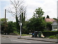
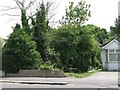
3
Tributary of the St. James Stream south of Woodmere Avenue, CR0 (2)
Image: © Mike Quinn
Taken: 26 May 2010
0.04 miles
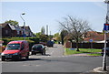
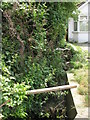
4
The eastern end of Woodmere Gardens, CR0
The low concrete wall (left) marks where a tributary of the St. James Stream passes underneath the road.
Image: © Mike Quinn
Taken: 26 May 2010
0.04 miles
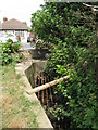
5
Woodmere Avenue, CR0
At the point that the Image passes underneath.
Image: © Mike Quinn
Taken: 26 May 2010
0.04 miles
6
Tributary of the St. James Stream south of Woodmere Avenue, CR0
Image: © Mike Quinn
Taken: 26 May 2010
0.04 miles

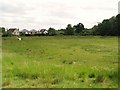
8
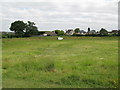
Balancing pond
A Image runs along the east side of this "pond".
Image: © Mike Quinn
Taken: 16 Jun 2010
0.06 miles