IMAGES TAKEN NEAR TO
Bingham Road, CROYDON, CR0 7EJ
Introduction
This page details the photographs taken nearby to Bingham Road, CR0 7EJ by members of the Geograph project.
The Geograph project started in 2005 with the aim of publishing, organising and preserving representative images for every square kilometre of Great Britain, Ireland and the Isle of Man.

There are currently over 7.5m images from over14,400 individuals and you can help contribute to the project by visiting https://www.geograph.org.uk
Image Map
Images are licensed for reuse under creativecommons.org/licenses/by-sa/2.0
Notes
- Clicking on the map will re-center to the selected point.
- The higher the marker number, the further away the image location is from the centre of the postcode.
Image Listing (32 Images Found)
Images are licensed for reuse under creativecommons.org/licenses/by-sa/2.0
Image
Details
Distance
1
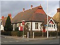
Christians in Action, Parkview Road
Built in 1914 as the Parkview Chapel (predecessor to St Mildred's church nearby). From 1934 a Brethren meeting house, and now the base of Christians in Action.
Image: © Stephen Craven
Taken: 11 Feb 2006
0.05 miles
2
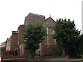
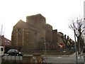
St. Mildred's Parish Church, Addiscombe (2)
This large church is on the junction of Sefton Road (in front) and Bingham Road (unseen, on the right).
Image: © David Anstiss
Taken: 16 Oct 2011
0.10 miles
3
St.Mildred's Parish Church, Addiscombe
This large church is on the junction of Sefton Road (in front) and Bingham Road (unseen, on the right).
The building in the foreground is the modern Vicarage.
Image: © David Anstiss
Taken: 16 Oct 2011
0.11 miles
4
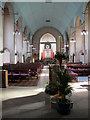
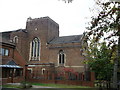
Interior of St Mildred?s church, Addiscombe
Looking from the back of the church towards the east end. The church was built in 1931 - 34 to the designs of C G Hare. See Image for an external view.
Image: © Stephen Craven
Taken: 19 Sep 2013
0.11 miles
5
St Mildred's Church, Bingham Road
Anglican parish church, built 1932.
Image: © Stephen Craven
Taken: 11 Feb 2006
0.11 miles
6
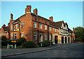
Woodside Fire Station
Woodside Fire Station, at 2 Long Lane, was built in 1933 as a sub station of the Croydon County Borough Fire Brigade, replacing a station in Shirley. The site was formerly occupied by a racecourse. In 1965 it was transferred to London.
Image: © Philip Talmage
Taken: 17 Aug 2005
0.12 miles
7
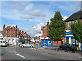
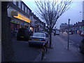
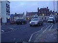
Lower Addiscombe Road, Addiscombe
Near the junction with Fernhurst Road and Blackhorse Lane.
Image: © Danny P Robinson
Taken: 21 Jun 2007
0.12 miles
8
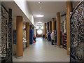
Lobby of St Mildred?s church, Addiscombe
The lobby is part of an extension to the church built c.2004.
Image: © Stephen Craven
Taken: 19 Sep 2013
0.14 miles