IMAGES TAKEN NEAR TO
Outram Road, CROYDON, CR0 6XE
Introduction
This page details the photographs taken nearby to Outram Road, CR0 6XE by members of the Geograph project.
The Geograph project started in 2005 with the aim of publishing, organising and preserving representative images for every square kilometre of Great Britain, Ireland and the Isle of Man.

There are currently over 7.5m images from over14,400 individuals and you can help contribute to the project by visiting https://www.geograph.org.uk
Image Map
Images are licensed for reuse under creativecommons.org/licenses/by-sa/2.0
Notes
- Clicking on the map will re-center to the selected point.
- The higher the marker number, the further away the image location is from the centre of the postcode.
Image Listing (165 Images Found)
Images are licensed for reuse under creativecommons.org/licenses/by-sa/2.0
Image
Details
Distance
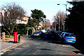
1
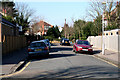
Croydon: Ashburton Gardens
Looking west along this very short cul de sac off the west side of Ashburton Road.
Image: © Dr Neil Clifton
Taken: 5 Mar 2010
0.01 miles
2
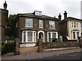
No.20 Outram Road, Addiscombe
House with a blue plaque.
Image: © David Anstiss
Taken: 16 Oct 2011
0.02 miles
3
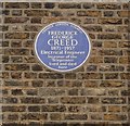
Frederick George Creed's Blue Plaque
On Image
See http://en.wikipedia.org/wiki/Frederick_G._Creed for more details about the telecommunications inventor.
Image: © David Anstiss
Taken: 16 Oct 2011
0.02 miles
4
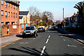
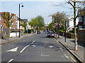
Croydon: Outram Road
Looking north from its T-junction with Addiscombe Road. At the far end of this straight road it ends at another T-junction with Lower Addiscombe Road.
Image: © Dr Neil Clifton
Taken: 5 Mar 2010
0.03 miles
5
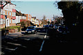
Croydon: Ashburton Road
Looking north from its T-junction with Addiscombe Road, Ashburton Road runs through to another T-junction with Lower Addiscombe Road at its far end.
Image: © Dr Neil Clifton
Taken: 5 Mar 2010
0.07 miles
6
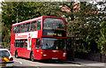
Croydon: Sandilands bus stop, eastbound
A Metrobus on Route 466, bound for Addington Village, calls at the Sandilands stop. This route starts from Caterham-on-the-Hill, Westway Common.
Image: © Dr Neil Clifton
Taken: 13 Sep 2006
0.07 miles
8
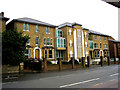
Croydon: South London Jamatkhana
Three large houses have been used to form this building: part of these was formerly used as a private school. The Jamatkhana is, as I understand it, a centre for the study of Ismaili, which is a sect of Islam led by the Aga Khan. It is on Addiscombe Road, should you wish to visit it, just opposite the Sandilands tram stop.
Image: © Dr Neil Clifton
Taken: 24 Feb 2010
0.08 miles
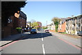
9
Havelock Road, Croydon
Looking north.
Image: © Robin Webster
Taken: 19 Apr 2019
0.08 miles
10
Croydon: Havelock Road
Looking north from the T-junction with Addiscombe Road. This road runs straight northwards to another T-junction with Lower Addiscombe Road.
Image: © Dr Neil Clifton
Taken: 5 Mar 2010
0.08 miles