IMAGES TAKEN NEAR TO
Tunstall Road, CROYDON, CR0 6TU
Introduction
This page details the photographs taken nearby to Tunstall Road, CR0 6TU by members of the Geograph project.
The Geograph project started in 2005 with the aim of publishing, organising and preserving representative images for every square kilometre of Great Britain, Ireland and the Isle of Man.

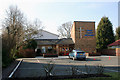
There are currently over 7.5m images from over14,400 individuals and you can help contribute to the project by visiting https://www.geograph.org.uk
Image Map
Images are licensed for reuse under creativecommons.org/licenses/by-sa/2.0
Notes
- Clicking on the map will re-center to the selected point.
- The higher the marker number, the further away the image location is from the centre of the postcode.
Image Listing (197 Images Found)
Images are licensed for reuse under creativecommons.org/licenses/by-sa/2.0
Image
Details
Distance
1
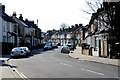
Croydon: Lebanon Road
Taken from its northern end at a T-junction with Leslie Park Road. Lebanon Road runs north to another T-junction with Addiscombe Road.
Image: © Dr Neil Clifton
Taken: 5 Mar 2010
0.07 miles
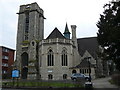
2
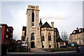
Croydon: Church of St. Mary Magdalene with St. Martin, Canning Road
Built in 1868-1870 and consecrated in 1878. Good clean lines in Portland stone.
Image: © Dr Neil Clifton
Taken: 3 Mar 2010
0.08 miles
3
Croydon: Church of St. Mary Magdalene with St. Martin, Canning Road
Image: © Dr Neil Clifton
Taken: 3 Mar 2010
0.08 miles
4
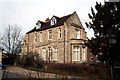
Croydon: St. Mary Magdalene vicarage, Canning Road
In the same Portland stone, this neatly matches the church next door and was designed by the same architect. Built 1870. They must have expected vicars to produce large families in those days.
Image: © Dr Neil Clifton
Taken: 3 Mar 2010
0.08 miles
5
Christ Church (Methodist), Lower Addiscombe Road
This modern church was built to replace one in Canning Road, now demolished.
Image: © Dr Neil Clifton
Taken: 5 Mar 2010
0.08 miles
6
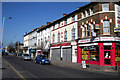
Croydon: Lower Addiscombe Road
North side, just west of Hastings Road
Image: © Dr Neil Clifton
Taken: 5 Mar 2010
0.08 miles
7
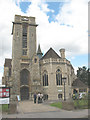
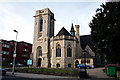
St Mary Magdalene, Addiscombe
An Anglican parish church, grade II* listed. When built in 1868, to the designs of Edward Buckton Lamb for the private patron Maxwell Ben Oliel (a convert from Judaism), it was known as St Paul's. It was later renamed for reasons given on this link: http://www.stmmm.org.uk/content.php?folder_id=83 .
The tower was not completed until 1930.
Image: © Stephen Craven
Taken: 21 Jul 2008
0.09 miles
9
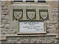
Consecration stone of St Mary Magdalene church
The stone records the consecration of the church on 31 July 1878 by the then Archbishop of Canterbury who at that time would have been Archibald Tait http://en.wikipedia.org/wiki/Archibald_Tait (until the 1980s, Croydon remained a detached part of Canterbury diocese).
The facts do not quite match the inscription (which was presumably made in anticipation of the event). According to the parish history, the Archbishop did not appear "due to an important debate in the House of Lords" and his son, Revd Crawford Tait, performed the ceremony on 5 August.
For context, see Image - the plaque is under the east window.
Image: © Stephen Craven
Taken: 21 Jul 2008
0.09 miles
10
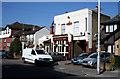
Croydon: The 'Builders Arms', Leslie Park Road
A comfortable 'regulars' pub, with a reputation for good beer.
Image: © Dr Neil Clifton
Taken: 5 Mar 2010
0.09 miles