IMAGES TAKEN NEAR TO
Pavement Square, CROYDON, CR0 6TL
Introduction
This page details the photographs taken nearby to Pavement Square, CR0 6TL by members of the Geograph project.
The Geograph project started in 2005 with the aim of publishing, organising and preserving representative images for every square kilometre of Great Britain, Ireland and the Isle of Man.

There are currently over 7.5m images from over14,400 individuals and you can help contribute to the project by visiting https://www.geograph.org.uk
Image Map
Images are licensed for reuse under creativecommons.org/licenses/by-sa/2.0
Notes
- Clicking on the map will re-center to the selected point.
- The higher the marker number, the further away the image location is from the centre of the postcode.
Image Listing (77 Images Found)
Images are licensed for reuse under creativecommons.org/licenses/by-sa/2.0
Image
Details
Distance
3
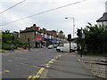
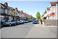
Lower Addiscombe Road, Croydon
Looking north-east from the Addiscombe tram crossing.
Image: © Dr Neil Clifton
Taken: 9 Jun 2009
0.06 miles
4

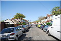
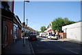
Addiscombe Telephone Exchange and Shops
The Telephone Exchange is on the corner of Addiscombe Road and Tevan Road.
Image: © Danny P Robinson
Taken: 21 Jun 2007
0.06 miles
5
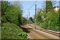
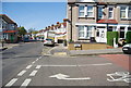
North of Addiscombe tramstop
The tram line crosses Lower Addiscombe Road at grade here, controlled by ordinary traffic lights. Previously, the railway had an overbridge here.
Image: © Dr Neil Clifton
Taken: 9 Jun 2009
0.06 miles
10
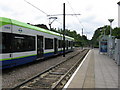
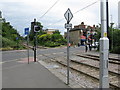
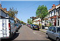
Addiscombe Tramstop
Car No 2544 is about to leave with a service towards central Croydon. The tramway here follows the course of an old railway, which, however, bridged over Bingham Road, at the far end of the tramstop, which is now a level crossing controlled by ordinary traffic lights
Image: © Dr Neil Clifton
Taken: 9 Jun 2009
0.09 miles