IMAGES TAKEN NEAR TO
Freemasons Road, CROYDON, CR0 6PD
Introduction
This page details the photographs taken nearby to Freemasons Road, CR0 6PD by members of the Geograph project.
The Geograph project started in 2005 with the aim of publishing, organising and preserving representative images for every square kilometre of Great Britain, Ireland and the Isle of Man.

There are currently over 7.5m images from over14,400 individuals and you can help contribute to the project by visiting https://www.geograph.org.uk
Image Map
Images are licensed for reuse under creativecommons.org/licenses/by-sa/2.0
Notes
- Clicking on the map will re-center to the selected point.
- The higher the marker number, the further away the image location is from the centre of the postcode.
Image Listing (120 Images Found)
Images are licensed for reuse under creativecommons.org/licenses/by-sa/2.0
Image
Details
Distance
1
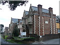
Davidson Lodge, Freemasons Road
Attractive Almshouses.
Image: © Peter Trimming
Taken: 19 Feb 2009
0.01 miles
2
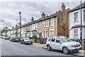
Davidson Road
Mid 19th Century houses on Davidson Road, most first marked on the 1871 6" map, when this section of the road was named Albert Road.
Image: © Ian Capper
Taken: 6 Jul 2024
0.03 miles
3
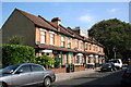
Croydon: Freemasons Road
This short road just gives access to the Freemasons Almshouses at the end. This picture shows houses 9 to 13 (consecutive).
Image: © Dr Neil Clifton
Taken: 14 Jun 2010
0.04 miles
4
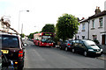
Croydon: Davidson Road
Looking north. The bus is on Route 410, Crystal Palace to Wallington
Image: © Dr Neil Clifton
Taken: 14 Jun 2010
0.04 miles
5
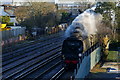
'Tangmere' Approaching East Croydon
Seen early on a Saturday morning; No.34067 'Tangmere', a Battle of Britain class Bulleid locomotive, seen with an empty stock movement for a steam excursion, from Three Bridges, to Bath and Bristol. Was I really up early enough to take this photograph at 07.18?
Image: © Peter Trimming
Taken: 19 Mar 2011
0.05 miles
6
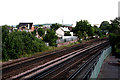
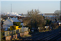
Croydon: Railway north of Windmill Bridge
Looking north. Very soon the main lines to Victoria and London Bridge diverge at Windmill Bridge Junction. Lines come in from West Croydon, and there is the Selhurst works.
In the picture centre-left the 'Drum and Monkey' on Gloucester Road can be seen.
Image: © Dr Neil Clifton
Taken: 14 Jun 2010
0.06 miles
7
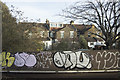
London Graffiti
This type of graffiti does nothing to enhance an area.
Image: © Malcolm Neal
Taken: 13 Feb 2019
0.07 miles
8
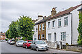
Davidson Road
Group of mid 19th Century houses on Davidson Road. The plaque on the front reads "Croydon Park Cottages 1870". The 1897 25" map, on which they are first marked, named this section of the road Albert Road.
Image: © Ian Capper
Taken: 6 Jul 2024
0.07 miles
9
Steam in the Landscape
View From the Lower Addiscombe Road railway bridge. In the distance, the two Crystal Palace transmitters can be seen; whilst in the middle distance, the trail of exhaust marks the progress of No.34067 'Tangmere' on an empty stock movement, having just passed through Selhurst station.
Image: © Peter Trimming
Taken: 19 Mar 2011
0.07 miles
10
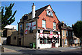
Croydon: The 'Drum and Monkey', Gloucester Road
Although the main signs (top left, and swinging sign on the front) have been blacked out, the 'Drum and Monkey' is still open, helped no doubt by interest just now in the World Cup.
Image: © Dr Neil Clifton
Taken: 14 Jun 2010
0.07 miles