IMAGES TAKEN NEAR TO
Amberley Grove, CROYDON, CR0 6ND
Introduction
This page details the photographs taken nearby to Amberley Grove, CR0 6ND by members of the Geograph project.
The Geograph project started in 2005 with the aim of publishing, organising and preserving representative images for every square kilometre of Great Britain, Ireland and the Isle of Man.

There are currently over 7.5m images from over14,400 individuals and you can help contribute to the project by visiting https://www.geograph.org.uk
Image Map
Images are licensed for reuse under creativecommons.org/licenses/by-sa/2.0
Notes
- Clicking on the map will re-center to the selected point.
- The higher the marker number, the further away the image location is from the centre of the postcode.
Image Listing (42 Images Found)
Images are licensed for reuse under creativecommons.org/licenses/by-sa/2.0
Image
Details
Distance
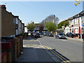
1
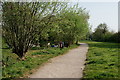
Addiscombe Railway Park
Addiscombe Railway Park is a 3.3 acres (1.3 ha) linear park. The first section of the park was opened on 26 May 2007, with the second section opened on 15 March 2010.
It occupies the track route and green buffering land of the demolished 'Addiscombe Line', a short railway that ran between Lower Addiscombe Road and Woodside Junction.
Image: © Peter Trimming
Taken: 11 Apr 2020
0.03 miles
2
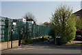
Addiscombe Railway Park
The southern entrance to the park.
Addiscombe Railway Park is a 3.3 acres (1.3 ha) linear park. The first section of the park was opened on 26 May 2007, with the second section opened on 15 March 2010.
It occupies the track route and green buffering land of the demolished 'Addiscombe Line', a short railway that ran between Lower Addiscombe Road and Woodside Junction.
Image: © Peter Trimming
Taken: 11 Apr 2020
0.04 miles
3
Addiscombe Railway Park
Addiscombe Railway Park is a 3.3 acres (1.3 ha) linear park. The first section of the park was opened on 26 May 2007, with the second section opened on 15 March 2010.
It occupies the track route and green buffering land of the demolished 'Addiscombe Line', a short railway that ran between Lower Addiscombe Road and Woodside Junction.
Image: © Peter Trimming
Taken: 11 Apr 2020
0.07 miles
4
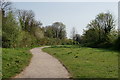
Addiscombe Railway Park
Addiscombe Railway Park is a 3.3 acres (1.3 ha) linear park. The first section of the park was opened on 26 May 2007, with the second section opened on 15 March 2010.
It occupies the track route and green buffering land of the demolished 'Addiscombe Line', a short railway that ran between Lower Addiscombe Road and Woodside Junction.
Image: © Peter Trimming
Taken: 11 Apr 2020
0.07 miles
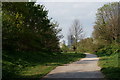
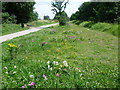
5
Dalmally Road, Addiscombe
Sundridge Road to the left.
Image: © Robin Webster
Taken: 19 Apr 2019
0.07 miles
6
Addiscombe Railway Park
The railway line from Beckenham via Woodside to Addiscombe Road Croydon was opened on 1st April 1864. In 1885, a line opened from Woodside to South Croydon and after that Addiscombe (as it eventually became after 1955) was on the end of a branch, poorly placed for the centre of Croydon. The Woodside & South Croydon Line was closed in 1983, but the Addiscombe branch remained open although there was little demand with some off peak trains running empty. By 1993, Woodside station had become unstaffed and Addiscombe booking office was only open during the morning peak hours. Following the announcement that the line from Elmers End to Woodside was to be incorporated into the Croydon Tramlink scheme, it was clear that the terminus at Addiscombe would close. The last day of service was Saturday 31st May 1997. The line now forms Addiscombe Railway Park which opened as a linear park in May 2007. This is three quarters of the way along the old branch and looks back in the direction of the former Woodside station, not to be confused with the new Woodside Tramlink stop - see http://www.geograph.org.uk/photo/2524945.
Image: © Marathon
Taken: 25 Jul 2011
0.10 miles
7
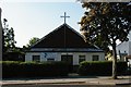
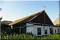
Addiscombe Baptist Church
These "tin tabernacles" were popular in the late nineteenth / early twentieth centuries: the church was supplied in effect in kit form. Often they were the first building erected by a congregation and might be replaced by a more permanent structure: the "tin tabernacle" could then be sold on to another congregation who were just starting out. Woodside Baptist Church to the northwest is a brick structure that replaced a tin tabernacle around the turn of the 19th /20th centuries.
Image: © Christopher Hilton
Taken: 24 May 2009
0.10 miles
8
Addiscombe Baptist Church
These "tin tabernacles" were popular in the late nineteenth / early twentieth centuries: the church was supplied in effect in kit form. Often they were the first building erected by a congregation and might be replaced by a more permanent structure: the "tin tabernacle" could then be sold on to another congregation who were just starting out. Woodside Baptist Church to the northwest is a brick structure that replaced a tin tabernacle around the turn of the 19th /20th centuries.
Image: © Christopher Hilton
Taken: 24 May 2009
0.10 miles
9
Addiscombe Baptist Church
These "tin tabernacles" were popular in the late nineteenth / early twentieth centuries: the church was supplied in effect in kit form. Often they were the first building erected by a congregation and might be replaced by a more permanent structure: the "tin tabernacle" could then be sold on to another congregation who were just starting out. Woodside Baptist Church to the northwest is a brick structure that replaced a tin tabernacle around the turn of the 19th /20th centuries.
Image: © Christopher Hilton
Taken: 24 May 2009
0.10 miles
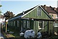
10
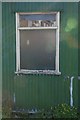
Addiscombe Baptist Church: window
These "tin tabernacles" were popular in the late nineteenth / early twentieth centuries: the church was supplied in effect in kit form. Often they were the first building erected by a congregation and might be replaced by a more permanent structure: the "tin tabernacle" could then be sold on to another congregation who were just starting out. Woodside Baptist Church to the northwest is a brick structure that replaced a tin tabernacle around the turn of the 19th /20th centuries.
Image: © Christopher Hilton
Taken: 24 May 2009
0.10 miles