IMAGES TAKEN NEAR TO
Paul Gardens, CROYDON, CR0 5QL
Introduction
This page details the photographs taken nearby to Paul Gardens, CR0 5QL by members of the Geograph project.
The Geograph project started in 2005 with the aim of publishing, organising and preserving representative images for every square kilometre of Great Britain, Ireland and the Isle of Man.

There are currently over 7.5m images from over14,400 individuals and you can help contribute to the project by visiting https://www.geograph.org.uk
Image Map
Images are licensed for reuse under creativecommons.org/licenses/by-sa/2.0
Notes
- Clicking on the map will re-center to the selected point.
- The higher the marker number, the further away the image location is from the centre of the postcode.
Image Listing (194 Images Found)
Images are licensed for reuse under creativecommons.org/licenses/by-sa/2.0
Image
Details
Distance
1
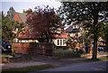
Greenhayes, Radcliffe Road
Until the late 1960s the west side of Radcliffe Road was occupied by substantial houses with large gardens and mature trees, while now there are maisonettes and side streets. A curious feature was the unmade footpaths at the side of the road, going back to its origins as a private road, which could be closed off from Addiscombe Road by a pair of large wooden gates. This lack of pavements remains, which is most strange. This was the house of the photographer, my grandfather, whose immediate family moved from the house in 1966 (a SOLD sign can be seen at the front gate).
Harold J. Thomas was a prolific amateur photographer, and I am sure that it is this memory from childhood and the hours spent in his darkroom at this house that has drawn me through a photographic obsession to Geograph today. My first camera (Kodak Brownie 127) was a Christmas present from him a year or two from the date of this image.
Image: © Harold J Thomas
Taken: Unknown
0.03 miles
2
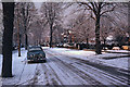
Radcliffe Road (1963)
Radcliffe Road seen under snowy conditions (see also Image) at Christmas 1963, and presenting a tree-lined aspect that endures today. Houses on the east side of the road are little changed, but maisonettes occupy much of the west side today, replacing larger houses with extensive gardens.
Image from the collection of my late grandfather, who lived here.
Image: © Harold J Thomas
Taken: Unknown
0.04 miles
3
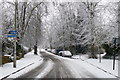
Radcliffe Road, Addiscombe, Croydon
One of the more "rural" looking roads near central Croydon. Being a side road, it does not appear to have been gritted, so the snow is still looking white.
Image: © Peter Trimming
Taken: 6 Jan 2010
0.09 miles
5
Sandilands Tramstop - Sat 20-09-2008 - flowering Choisya
Sat 20-Sep-2008 about 16:45 – Sandilands Tramstop – East end of North platform – looking west towards Croydon – No 3 to New Addington – Choisya ternata (Mexican Orange) in lower right of picture
Image: © Daniel Roe
Taken: 20 Sep 2008
0.11 miles
6
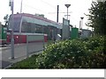
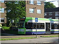
Croydon Trams in the Snow (6)
West Croydon tram heads for East Croydon, as the snow falls steadily.
Image: © Peter Trimming
Taken: 6 Jan 2010
0.13 miles
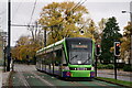
8
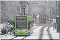
Croydon Trams in the Snow (5)
West Croydon tram, heading for East Croydon, having just left the Sandilands tram stop.
Image: © Peter Trimming
Taken: 6 Jan 2010
0.13 miles
9
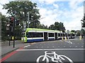
Tram crossing
Tram crossing just west of Sandilands tram stop.
Image: © Malc McDonald
Taken: 22 May 2010
0.13 miles
10
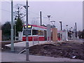
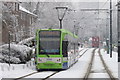
Tramlink
Due to signalling problems, the Beckenham Junction services were being terminated at Harrington Road.
Image: © Peter Trimming
Taken: 14 Nov 2021
0.13 miles