IMAGES TAKEN NEAR TO
Granville Close, CROYDON, CR0 5PX
Introduction
This page details the photographs taken nearby to Granville Close, CR0 5PX by members of the Geograph project.
The Geograph project started in 2005 with the aim of publishing, organising and preserving representative images for every square kilometre of Great Britain, Ireland and the Isle of Man.

There are currently over 7.5m images from over14,400 individuals and you can help contribute to the project by visiting https://www.geograph.org.uk
Image Map
Images are licensed for reuse under creativecommons.org/licenses/by-sa/2.0
Notes
- Clicking on the map will re-center to the selected point.
- The higher the marker number, the further away the image location is from the centre of the postcode.
Image Listing (387 Images Found)
Images are licensed for reuse under creativecommons.org/licenses/by-sa/2.0
Image
Details
Distance
1
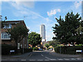
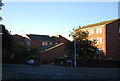
Granville Close, Croydon
A dead-end side road off Park Hill Road. In the distance, the Altitude 25 tower Image
Image: © Stephen Craven
Taken: 6 Aug 2013
0.01 miles
2

Road Scene, Fairfield Road, Croydon
The view is towards Central Croydon, with Altitude 25, Croydon's newest, and tallest, tower block seen in the middle distance.
I thought that the road was unusually quiet for mid afternoon, from my vantage point of a pedestrian island between two pedestrian crossings. When I looked to my left, I realised why ..... a Police car had pulled up, and an officer politely asked "Could I have a word?". Having checked my identity, and viewed some of my pictures, the officers were happy to go on their way.
Image: © Peter Trimming
Taken: 15 Apr 2009
0.04 miles
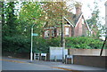
3
Roundabout on Park Hill Road
The roundabout is at the junction of A2039 Park Hill Road (foreground) and Chepstow Road.
Image: © Stephen Craven
Taken: 6 Aug 2013
0.05 miles
4
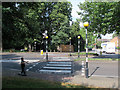
Zebra crossing on Park Hill Road
The crossing is adjacent to the roundabout Image and on the other side continues into an urban footpath to The Avenue.
Image: © Stephen Craven
Taken: 6 Aug 2013
0.07 miles
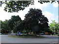
8
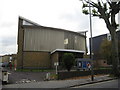
East Croydon United Reformed Church building
Image: © Richard Rogerson
Taken: 5 Nov 2009
0.09 miles
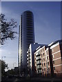
9
Addiscombe Grove, Croydon
Towering over the traffic queue, the NLA Tower as it is currently known (but, to Croydonians for some decades, the "Threepenny bit").
Image: © Christopher Hilton
Taken: 2 Apr 2015
0.10 miles
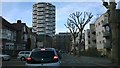
10
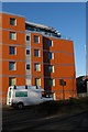
Latitude 25, Croydon
The five-story block of flats here, Latitude 25, stretches along Addiscombe Grove and forms part of a single development with Croydon's (then) tallest block of flats, Altitude 25 Image The names are presumably chosen to reflect the fact that one goes up and the other along.
Image: © Christopher Hilton
Taken: 9 Mar 2014
0.10 miles