IMAGES TAKEN NEAR TO
Turnpike Link, CROYDON, CR0 5NW
Introduction
This page details the photographs taken nearby to Turnpike Link, CR0 5NW by members of the Geograph project.
The Geograph project started in 2005 with the aim of publishing, organising and preserving representative images for every square kilometre of Great Britain, Ireland and the Isle of Man.

There are currently over 7.5m images from over14,400 individuals and you can help contribute to the project by visiting https://www.geograph.org.uk
Image Map
Images are licensed for reuse under creativecommons.org/licenses/by-sa/2.0
Notes
- Clicking on the map will re-center to the selected point.
- The higher the marker number, the further away the image location is from the centre of the postcode.
Image Listing (230 Images Found)
Images are licensed for reuse under creativecommons.org/licenses/by-sa/2.0
Image
Details
Distance
2
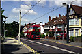
Lebanon Road bus stop
When trams were re-introduced in the Croydon area, changes were made to the bus routes. The long Route 54 between Woolwich and West Croydon was duplicated by the trams from Elmers End to Croydon, so after a short period of grace, the bus route was cut back to Elmers End Green. Here an eastbound Olympian on Route 54 makes one of the last journeys along Addiscombe Road
Image: © Dr Neil Clifton
Taken: 8 Jun 2000
0.04 miles
3
Lebanon Road bus stop
See Image Here a Route 54 bus is on one of its last journeys along Addiscombe Road, westbound into Croydon.
Image: © Dr Neil Clifton
Taken: 8 Jun 2000
0.04 miles
4
Lebanon Road tram stop
Car 2540 is on a westbound trip to Wimbledon. Behind it, another tram can be seen in a turquoise livery advertising the Whitgift shopping centre.
Image: © Dr Neil Clifton
Taken: 8 Jun 2000
0.04 miles
5
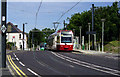
Croydon: Lebanon Road tram stop
Car No 2550, travelling away from the camera, is inward-bound for West Croydon.
Image: © Dr Neil Clifton
Taken: 3 Mar 2010
0.04 miles
6
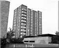
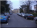
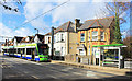
High Life in Croydon, 1979 style
These private apartments on Croydon's Park Hill were at the opposite end of the spectrum from council blocks. With entry phones and 24-hour janitor service they were priced to match, but they still sold well. And why not? You could walk to East Croydon station and be in the City within a comfortable half-hour.
Image: © Dr Neil Clifton
Taken: 30 Sep 1979
0.04 miles
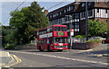
8
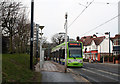
Lebanon Road Tram Stop
For the most part the tramlink lines use old railway routes or run in dedicated tram corridors, but along here they are genuine street trams sharing the road with other vehicles.
This is Addiscombe Road. Lebanon Road is a side street nearby.
Image: © Des Blenkinsopp
Taken: 11 Feb 2020
0.05 miles
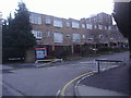
9
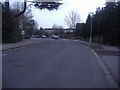
1970s Living in Croydon
New houses on Park Hill Estate, Croydon, Surrey
Image: © Dr Neil Clifton
Taken: 30 Sep 1979
0.06 miles