IMAGES TAKEN NEAR TO
Stanhope Road, CROYDON, CR0 5NS
Introduction
This page details the photographs taken nearby to Stanhope Road, CR0 5NS by members of the Geograph project.
The Geograph project started in 2005 with the aim of publishing, organising and preserving representative images for every square kilometre of Great Britain, Ireland and the Isle of Man.

There are currently over 7.5m images from over14,400 individuals and you can help contribute to the project by visiting https://www.geograph.org.uk
Image Map
Images are licensed for reuse under creativecommons.org/licenses/by-sa/2.0
Notes
- Clicking on the map will re-center to the selected point.
- The higher the marker number, the further away the image location is from the centre of the postcode.
Image Listing (102 Images Found)
Images are licensed for reuse under creativecommons.org/licenses/by-sa/2.0
Image
Details
Distance
1
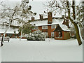
Red Court Nursing Home
A BUPA establishment.
Image: © Robin Webster
Taken: 19 Dec 2010
0.03 miles
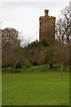
2
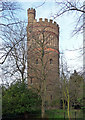
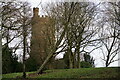
Water tower, Water Tower Hill
The Victorians customarily put an impressive amount of effort into even utilitarian structures such as this. It was the work of Baldwin Latham, the Borough Engineer, in 1867, designed in a neo-Norman style with ornamental brickwork and a bartizan. It was gutted in 1971, and now sits in public park behind a fence. Grade II listed.
Image: © Stephen Richards
Taken: 20 Mar 2011
0.04 miles
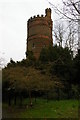
3
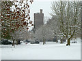
Park Hill Water Tower, Croydon
A grade II listed building from 1867.
Image: © Robin Webster
Taken: 19 Dec 2010
0.04 miles
4
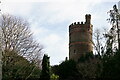
Croydon
The water tower at Park Hill.
Image: © Peter Trimming
Taken: 17 Jan 2021
0.04 miles
5
Croydon
The water tower at Park Hill.
Image: © Peter Trimming
Taken: 17 Jan 2021
0.04 miles
8
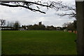
Croydon: Park Hill, Water Tower, from the Vanguard Way
The Vanguard Way runs south-east out of Croydon following the Fairfield Path, an ancient right of way that cuts across modern housing developments on Park Hill.
Image: © Christopher Hilton
Taken: 13 Mar 2011
0.04 miles
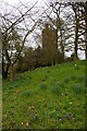
10

Croydon: Park Hill, water tower and herb garden
Image: © Christopher Hilton
Taken: 13 Mar 2011
0.04 miles