IMAGES TAKEN NEAR TO
Langton Way, CROYDON, CR0 5BQ
Introduction
This page details the photographs taken nearby to Langton Way, CR0 5BQ by members of the Geograph project.
The Geograph project started in 2005 with the aim of publishing, organising and preserving representative images for every square kilometre of Great Britain, Ireland and the Isle of Man.

There are currently over 7.5m images from over14,400 individuals and you can help contribute to the project by visiting https://www.geograph.org.uk
Image Map
Images are licensed for reuse under creativecommons.org/licenses/by-sa/2.0
Notes
- Clicking on the map will re-center to the selected point.
- The higher the marker number, the further away the image location is from the centre of the postcode.
Image Listing (98 Images Found)
Images are licensed for reuse under creativecommons.org/licenses/by-sa/2.0
Image
Details
Distance

8
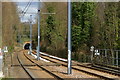
Tramlink Track Near Lloyd Park
At this location, Tramlink utilises the trackbed of the former railway line to Woodside. Note the distant tunnel, which is several hundred yards long.
Image: © Peter Trimming
Taken: 11 Mar 2011
0.10 miles
9
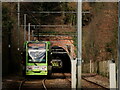
Tramlink
A West Croydon service approaching the Sandilands Tunnel.
Image: © Peter Trimming
Taken: 14 Mar 2023
0.10 miles
10

Vixen on the Prowl (2)
She was obviously lactating, so probably heading home to her den or out to find food.
Image]
Image: © Peter Trimming
Taken: 14 Mar 2023
0.11 miles