IMAGES TAKEN NEAR TO
Purley Way, CROYDON, CR0 4XJ
Introduction
This page details the photographs taken nearby to Purley Way, CR0 4XJ by members of the Geograph project.
The Geograph project started in 2005 with the aim of publishing, organising and preserving representative images for every square kilometre of Great Britain, Ireland and the Isle of Man.

There are currently over 7.5m images from over14,400 individuals and you can help contribute to the project by visiting https://www.geograph.org.uk
Image Map
Images are licensed for reuse under creativecommons.org/licenses/by-sa/2.0
Notes
- Clicking on the map will re-center to the selected point.
- The higher the marker number, the further away the image location is from the centre of the postcode.
Image Listing (193 Images Found)
Images are licensed for reuse under creativecommons.org/licenses/by-sa/2.0
Image
Details
Distance
2
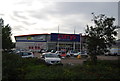
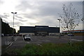
Evening showers over the retail parks, Purley Way, Croydon
A series of heavy showers had left the car parks glistening with rain as the sun dipped lower.
Image: © Christopher Hilton
Taken: 2 Sep 2015
0.01 miles
3
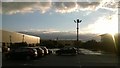
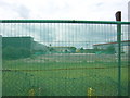
Vacant land, Purley Way, Croydon
Between the car parks of PC World and John Lewis, a vacant plot awaits the Purley Way's next big retail shed.
Three years previously it was already vacant and can be seen looking the other way on Image, on which the flanking retail units are visible.
Image: © Christopher Hilton
Taken: 4 Oct 2014
0.03 miles
4
Temple of Convenience: John Lewis, Purley Way, welcomes shoppers to the January sales
Image: © Christopher Hilton
Taken: 2 Jan 2014
0.03 miles
6
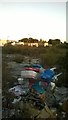
Vacant plot, Purley Way
Earmarked eventually for another big retail shed. Three years on, it was still standing empty, and can be seen looking in the other direction in Image
Image: © Christopher Hilton
Taken: 9 Jul 2011
0.04 miles
7
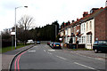
Croydon: Mill Lane
Looking east. There are houses on the north side only, numbered 12 to 1, consecutively. At the far end is a crossroads with traffic lights: Purley Way (A23) to left and right, and Waddon Road straight ahead.
Image: © Dr Neil Clifton
Taken: 14 Mar 2010
0.05 miles
8
Croydon: Mill Lane
Looking west. Mill Lane runs west from its junction with Purley Way to serve some industrial premises at the west end, but there is no vehicular outlet at that end. There are houses only on the north side of Mill Lane, and they are numbered consecutively, 1 to 12 from the near (east) end.
Image: © Dr Neil Clifton
Taken: 14 Mar 2010
0.07 miles
9

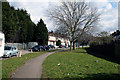
Terraced cottages and construction on Purley Way
These cottages survive squeezed between heavy traffic and retail sheds; now added to that are the new housing blocks of Croydon's New South Quarter, a development on former industrial land.
Image: © Christopher Hilton
Taken: 4 Oct 2014
0.08 miles
10
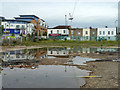
Puddles and premises, Purley Way
The puddles are in a vacant site which has got left behind in the conversion of this area from industry to large retail stores.
Image: © Robin Webster
Taken: 6 Jun 2011
0.08 miles