IMAGES TAKEN NEAR TO
Twickenham Close, CROYDON, CR0 4SZ
Introduction
This page details the photographs taken nearby to Twickenham Close, CR0 4SZ by members of the Geograph project.
The Geograph project started in 2005 with the aim of publishing, organising and preserving representative images for every square kilometre of Great Britain, Ireland and the Isle of Man.

There are currently over 7.5m images from over14,400 individuals and you can help contribute to the project by visiting https://www.geograph.org.uk
Image Map
Images are licensed for reuse under creativecommons.org/licenses/by-sa/2.0
Notes
- Clicking on the map will re-center to the selected point.
- The higher the marker number, the further away the image location is from the centre of the postcode.
Image Listing (163 Images Found)
Images are licensed for reuse under creativecommons.org/licenses/by-sa/2.0
Image
Details
Distance
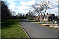
1
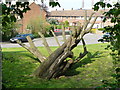
Tree in Beddington
Tree, or art form? Leaning over at a drunken angle, and blown by the prevailing wind, it will be interesting to see how this tree recovers from its recent pruning. The houses in Richmond Green appear in the background.
Image: © Peter Trimming
Taken: 20 Apr 2009
0.03 miles
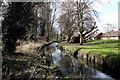
2
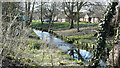
River Wandle at Beddington
Close to Waddon Ponds, this is not the most attractive stretch of the river.
Image: © Peter Trimming
Taken: 2 Mar 2009
0.04 miles
3
Beddington: Richmond Green
Looking east. The River Wandle is on the right.
Image: © Dr Neil Clifton
Taken: 14 Mar 2010
0.04 miles
4
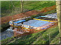
River Wandle at Beddington
There was an oil spillage, on 9th March 2009, which affected the River Wandle. I assume that the set-up, in this photograph, ensures that only clean water flows beyond this point. Certainly, there was a heavy smell of oil in this location, which was gone just 50 yards up river.
Image: © Peter Trimming
Taken: 17 Mar 2009
0.05 miles
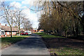
5
Beddington: Richmond Green
Looking west. The River Wandle is to the left, but out of view. The houses on Richmond Green are bungalows, mainly occupied by retired people.
Image: © Dr Neil Clifton
Taken: 14 Mar 2010
0.06 miles
6
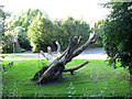
Dead tree by the Wandle
A tree on Richmond Green Image viewed from the footpath on the other side of the river.
Image: © Stephen Craven
Taken: 19 Aug 2012
0.07 miles
7
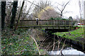
Beddington: Footbridge over the River Wandle
Looking west. This bridge connects Lavington Road, on the south bank, with Richmond Green on the north bank.
Image: © Dr Neil Clifton
Taken: 22 Mar 2010
0.07 miles
8
Beddington: River Wandle, looking west
As the River Wandle runs out of Croydon and into Sutton, it emerges into the open air from the culvert system that has carried it under Croydon. The Wandle here is carrying excess water from Waddon Ponds as well as land water that has drained into it in Croydon
Image: © Dr Neil Clifton
Taken: 14 Mar 2010
0.07 miles
9
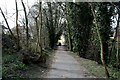
Beddington: The Wandle Trail
Looking west from the end of Aldwick Road
Image: © Dr Neil Clifton
Taken: 14 Mar 2010
0.07 miles
10
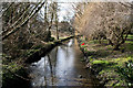
Beddington: River Wandle, looking downstream
View west from the footbridge at the end of Lavington Road
Image: © Dr Neil Clifton
Taken: 14 Mar 2010
0.07 miles