IMAGES TAKEN NEAR TO
Purley Way, CROYDON, CR0 4RQ
Introduction
This page details the photographs taken nearby to Purley Way, CR0 4RQ by members of the Geograph project.
The Geograph project started in 2005 with the aim of publishing, organising and preserving representative images for every square kilometre of Great Britain, Ireland and the Isle of Man.

There are currently over 7.5m images from over14,400 individuals and you can help contribute to the project by visiting https://www.geograph.org.uk
Image Map
Images are licensed for reuse under creativecommons.org/licenses/by-sa/2.0
Notes
- Clicking on the map will re-center to the selected point.
- The higher the marker number, the further away the image location is from the centre of the postcode.
Image Listing (85 Images Found)
Images are licensed for reuse under creativecommons.org/licenses/by-sa/2.0
Image
Details
Distance
1
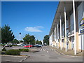
Leisure complex on Purley Way
Housing various food and entertainment establishments.
Image: © Rod Allday
Taken: 26 Jun 2011
0.03 miles
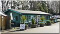
2
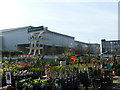
Wyevale Garden Centre, Purley Way
Sadly, this Garden Centre has lost its water feature, as it was built on the site of the Purley Way open air swimming pool. However, to the left of picture, the diving boards have been retained, which make an interesting garden feature.
Image: © Peter Trimming
Taken: 17 Mar 2009
0.03 miles
3
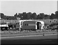
"Pikeys" at Purley Way
Before it was developed, this waste ground at the corner of Purley Way playing fields was often visited by itinerant caravan dwellers, who are known by many names, most of them abusive.
Image: © Dr Neil Clifton
Taken: 17 Sep 1978
0.06 miles
5
Caf? at Wyevale Garden Centre, Purley Way
A nice place to relax after a trip to the Garden Centre.
Image: © Peter Trimming
Taken: 17 Mar 2009
0.07 miles
6
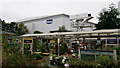
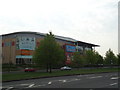
Wyevale Garden Centre
The garden centre was built on the site of the Purley Way open air swimming pool. To the right of picture, the diving boards have been retained (listed structure), which make an interesting garden feature.
Image: © Peter Trimming
Taken: 22 Sep 2018
0.09 miles
7
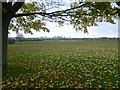
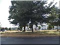
Purley Way Playing Fields
The playing fields consisted entirely of former agricultural land which was levelled and grassed to make playing fields. During the Second World War the ground was again used to cultivate crops. By 1946, 25 acres of the playing field had been reinstated as playing area and by 1948 plans had been made to reinstate another 60 acres. There are fine views of central Croydon's "Manhatten" skyline from the playing field as seen here, but the attraction used to be the arrival and departure of aeroplanes from London Airport on the west side of Purley Way.
Image: © Marathon
Taken: 7 Nov 2012
0.09 miles
8
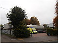
South Croydon Ambulance Station
On Waddon Way, near Purley Way Playing Fields.
Image: © David Anstiss
Taken: 30 Oct 2011
0.10 miles
9
The old Croydon Airport
This was the original London Airport when people first started flying abroad, to be replaced by Heathrow.
Image: © David Howard
Taken: 8 Jul 2018
0.10 miles
10
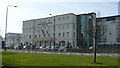
Aerodrome Hotel, Purley way
The hotel was named after Croydon Aerodrome, situated immediately to the south-west of the hotel.
Image: © Peter Trimming
Taken: 17 Mar 2009
0.11 miles