IMAGES TAKEN NEAR TO
Siddons Road, CROYDON, CR0 4JR
Introduction
This page details the photographs taken nearby to Siddons Road, CR0 4JR by members of the Geograph project.
The Geograph project started in 2005 with the aim of publishing, organising and preserving representative images for every square kilometre of Great Britain, Ireland and the Isle of Man.

There are currently over 7.5m images from over14,400 individuals and you can help contribute to the project by visiting https://www.geograph.org.uk
Image Map
Images are licensed for reuse under creativecommons.org/licenses/by-sa/2.0
Notes
- Clicking on the map will re-center to the selected point.
- The higher the marker number, the further away the image location is from the centre of the postcode.
Image Listing (315 Images Found)
Images are licensed for reuse under creativecommons.org/licenses/by-sa/2.0
Image
Details
Distance
1
Croydon: Siddons Road
Looking east from the start of this road at a T-junction with Vicarage Road. Although the high-rise buildings of Central Croydon are visible in the photograph, there is no through route to reach them this way.
Image: © Dr Neil Clifton
Taken: 22 Mar 2010
0.01 miles
2
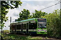
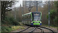
Tramlink
Tram approaching the Wandle Park tram stop, seen from the edge of the park.
Image: © Peter Trimming
Taken: 18 May 2021
0.03 miles
3

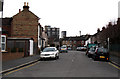
Street Scene, Kemble Road, Croydon
Houses on the left side of the road, and a steep bank on the right side. Waddon Road runs along the top of the bank, gaining height to pass over the railway line.
Image: © Peter Trimming
Taken: 20 Apr 2009
0.03 miles
4
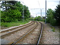
Tramlink east of Wandle Park Tramlink Stop
The Wimbledon to West Croydon Line was opened in 1855 and closed in 1997 so that the route could be taken over by Tramlink. The original line between Wimbledon and West Croydon just ran as a shuttle between those two stations and although it was electrified in 1930, trains on the line never continued elsewhere. In its latter years trains ran about every 45 minutes. Some sections were single line and this continued when Tramlink took over the route. Just beyond Wandle Park Tramlink Stop, in the direction facing here, the line reverts to single track for a short while. Wandle Park is on the left and this photograph is taken from the foot crossing between the park and Vicarage Road.
Image: © Marathon
Taken: 16 May 2012
0.03 miles
5
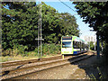
Tram entering single track section
The tram is approaching Croydon, and going on to the single-track section on the bridge over the National Rail tracks Image This is just east of the Vicarage Road pedestrian crossing of the tram line.
Image: © Stephen Craven
Taken: 19 Aug 2012
0.03 miles
6
Tramlink
Wimbledon tram approaching the Wandle Park stop. Croydon Minster can be seen in the background.
Image: © Peter Trimming
Taken: 5 Jan 2025
0.03 miles
7

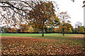
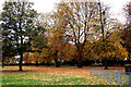
Wandle Park
One of the park residents. It is not obvious from this picture, but the squirrel has lost virtually all of her tail and her rear right paw. These appear to be old injuries and she has learned to adapt quite well.
Image]
Image: © Peter Trimming
Taken: 18 May 2021
0.03 miles
8

Wandle Park
One of the park residents. The squirrel has lost virtually all of her tail and her rear right paw. These appear to be old injuries and she has learned to adapt quite well, she is eating with one paw rather than the usual two in order to maintain two points of contact on the branch.
Image]
Image: © Peter Trimming
Taken: 18 May 2021
0.03 miles