IMAGES TAKEN NEAR TO
Violet Gardens, CROYDON, CR0 4HT
Introduction
This page details the photographs taken nearby to Violet Gardens, CR0 4HT by members of the Geograph project.
The Geograph project started in 2005 with the aim of publishing, organising and preserving representative images for every square kilometre of Great Britain, Ireland and the Isle of Man.

There are currently over 7.5m images from over14,400 individuals and you can help contribute to the project by visiting https://www.geograph.org.uk
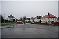
Image Map
Images are licensed for reuse under creativecommons.org/licenses/by-sa/2.0
Notes
- Clicking on the map will re-center to the selected point.
- The higher the marker number, the further away the image location is from the centre of the postcode.
Image Listing (52 Images Found)
Images are licensed for reuse under creativecommons.org/licenses/by-sa/2.0
Image
Details
Distance
2
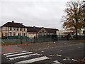
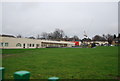
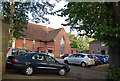
Aeroplane Primary School, South Croydon
School on Goodwin Road.
Image: © David Anstiss
Taken: 30 Oct 2011
0.08 miles
6
Houses in Goodwin Road
On the edge of the estate, with Purley Way playing fields just yards away.
Image: © Peter Trimming
Taken: 17 Mar 2009
0.09 miles
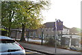
9
St Dominic's Catholic Church, Violet Lane
Image: © N Chadwick
Taken: 9 Oct 2011
0.10 miles
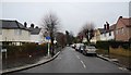
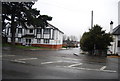
10
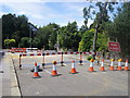
Whitgift Avenue
A closed Whitgift Avenue at the junction with Hayling Park Road
Image: © Shaun Ferguson
Taken: 26 Jun 2012
0.10 miles