IMAGES TAKEN NEAR TO
Old School Place, CROYDON, CR0 4GB
Introduction
This page details the photographs taken nearby to Old School Place, CR0 4GB by members of the Geograph project.
The Geograph project started in 2005 with the aim of publishing, organising and preserving representative images for every square kilometre of Great Britain, Ireland and the Isle of Man.

There are currently over 7.5m images from over14,400 individuals and you can help contribute to the project by visiting https://www.geograph.org.uk
Image Map
Images are licensed for reuse under creativecommons.org/licenses/by-sa/2.0
Notes
- Clicking on the map will re-center to the selected point.
- The higher the marker number, the further away the image location is from the centre of the postcode.
Image Listing (58 Images Found)
Images are licensed for reuse under creativecommons.org/licenses/by-sa/2.0
Image
Details
Distance
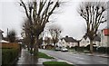
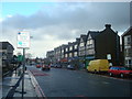
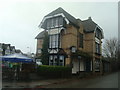
3
Coldharbour Rd , Denning Avenue junction
Image: © N Chadwick
Taken: 27 Feb 2011
0.12 miles
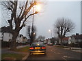
5
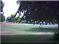
Duppas Hill Recreation Ground.
Between Duppas Hill Road (A232) and Cooper Road.
Image: © Noel Foster
Taken: 27 Jun 2005
0.13 miles
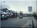
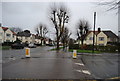
8
Page Crescent, Waddon Estate, South Croydon
Page Crescent is a residential road in South Croydon, in the outer suburbs of south London. It forms part of the Waddon Estate.
This image was taken on a February afternoon, as the sun was setting.
Image: © Malc McDonald
Taken: 19 Feb 2023
0.16 miles
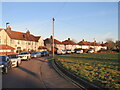
10
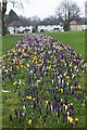
Crocuses in Waddon
A fine display of spring flowers in Croydon.
Image: © patrick connolly
Taken: 1 Mar 2009
0.16 miles