IMAGES TAKEN NEAR TO
Cabot Close, CROYDON, CR0 4FP
Introduction
This page details the photographs taken nearby to Cabot Close, CR0 4FP by members of the Geograph project.
The Geograph project started in 2005 with the aim of publishing, organising and preserving representative images for every square kilometre of Great Britain, Ireland and the Isle of Man.

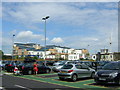
There are currently over 7.5m images from over14,400 individuals and you can help contribute to the project by visiting https://www.geograph.org.uk
Image Map
Images are licensed for reuse under creativecommons.org/licenses/by-sa/2.0
Notes
- Clicking on the map will re-center to the selected point.
- The higher the marker number, the further away the image location is from the centre of the postcode.
Image Listing (172 Images Found)
Images are licensed for reuse under creativecommons.org/licenses/by-sa/2.0
Image
Details
Distance
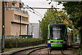
1
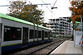
Waddon: South Quarter redevelopment
A westbound tram leaves the Wandle Park stop, where despite the financial crisis, the redevelopment of the South Quarter area is proceeding apace.
Image: © Dr Neil Clifton
Taken: 3 Nov 2010
0.04 miles
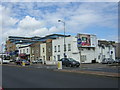
2
Rigby Road, Croydon
Houses on either side of the road, and flats at the end. The cranes on the skyline are working on a development just off the Purley Way (A23).
Image: © Peter Trimming
Taken: 20 Apr 2009
0.06 miles
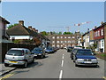
3
Purley Way (A23), Croydon
A lull in the traffic makes this shot much easier. On the right side of the road, the houses are at least 100 years old, whilst in the background, a new development makes its appearance on the skyline.
Image: © Peter Trimming
Taken: 20 Apr 2009
0.07 miles
5
Croydon: New South Quarter from John Lewis car park
New South Quarter is a large housing development recently built on vacant land along the Purley Way (the 1920s Croydon by-pass). The whole landscape around the middle Purley Way is a Ballardesque expanse of dual carriageway, car parks and retail sheds.
For the other side of New South Quarter, see Image
Image: © Christopher Hilton
Taken: 9 Jul 2011
0.08 miles
6
Purley Way, Croydon: Victorian terrace and New South Quarter beyond
New South Quarter is a large housing development recently built on vacant land along the Purley Way (the 1920s Croydon by-pass). The whole landscape around the middle Purley Way is a Ballardesque expanse of dual carriageway, car parks and retail sheds, with a few Victorian cottages stranded in the middle of it.
Image: © Christopher Hilton
Taken: 9 Jul 2011
0.08 miles
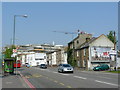
7
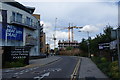
New development on Whitestone Way
An encouraging view for the economy.
Image: © Bill Boaden
Taken: 2 Aug 2014
0.08 miles
8
Terraced cottages on Purley Way
Squeezed between heavy traffic and retail sheds a few Victorian terraces cling on.
Image: © Christopher Hilton
Taken: 4 Oct 2014
0.08 miles
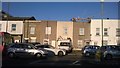
9

Terraced cottages and construction on Purley Way
These cottages survive squeezed between heavy traffic and retail sheds; now added to that are the new housing blocks of Croydon's New South Quarter, a development on former industrial land.
Image: © Christopher Hilton
Taken: 4 Oct 2014
0.08 miles
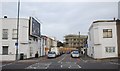
10
Tramlink
With planned engineering work severing the line, trams shuttled between Wimbledon and Croydon, terminating at Wandle Park.
Part of the fleet operated from East Croydon to the other destinations.
Image: © Peter Trimming
Taken: 24 Oct 2020
0.08 miles