IMAGES TAKEN NEAR TO
Chapman Road, CROYDON, CR0 3NX
Introduction
This page details the photographs taken nearby to Chapman Road, CR0 3NX by members of the Geograph project.
The Geograph project started in 2005 with the aim of publishing, organising and preserving representative images for every square kilometre of Great Britain, Ireland and the Isle of Man.

There are currently over 7.5m images from over14,400 individuals and you can help contribute to the project by visiting https://www.geograph.org.uk
Image Map
Images are licensed for reuse under creativecommons.org/licenses/by-sa/2.0
Notes
- Clicking on the map will re-center to the selected point.
- The higher the marker number, the further away the image location is from the centre of the postcode.
Image Listing (51 Images Found)
Images are licensed for reuse under creativecommons.org/licenses/by-sa/2.0
Image
Details
Distance
1
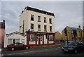
The Holy Redeemer St. Mark's Mission, Broad Green
Modern Church on the junction of Chapman Road (on the left) and Kingsley Road (on the right).
Image: © David Anstiss
Taken: 30 Oct 2011
0.01 miles
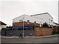
3
Kingsley Primary School, Broad Green
This school is on Thompson Crescent.
Image: © David Anstiss
Taken: 30 Oct 2011
0.06 miles
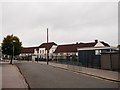
5
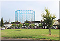
Green and Gasometer, Euston Road
One of the landmark gas holder frames from the former Croydon gas works looms above the houses which surround this small green.
Image: © Des Blenkinsopp
Taken: 16 Aug 2018
0.09 miles