IMAGES TAKEN NEAR TO
Miller Road, CROYDON, CR0 3JZ
Introduction
This page details the photographs taken nearby to Miller Road, CR0 3JZ by members of the Geograph project.
The Geograph project started in 2005 with the aim of publishing, organising and preserving representative images for every square kilometre of Great Britain, Ireland and the Isle of Man.

There are currently over 7.5m images from over14,400 individuals and you can help contribute to the project by visiting https://www.geograph.org.uk
Image Map
Images are licensed for reuse under creativecommons.org/licenses/by-sa/2.0
Notes
- Clicking on the map will re-center to the selected point.
- The higher the marker number, the further away the image location is from the centre of the postcode.
Image Listing (94 Images Found)
Images are licensed for reuse under creativecommons.org/licenses/by-sa/2.0
Image
Details
Distance
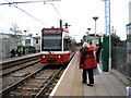
1
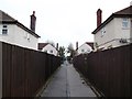
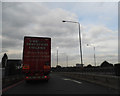
Path to Miller Road
A straight path leads from Ampere Way, over the Croydon Tramlink, leading towards Miller Road, and onwards to the A236 Mitcham Road.
Image: © David Anstiss
Taken: 30 Oct 2011
0.03 miles
2
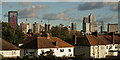
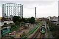
Croydon Skyline
View from the Purley Way bridge over the Tramlink line.
Image: © Peter Trimming
Taken: 4 Nov 2022
0.07 miles
3
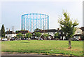
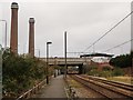
Green and Gasometer, Euston Road
One of the landmark gas holder frames from the former Croydon gas works looms above the houses which surround this small green.
Image: © Des Blenkinsopp
Taken: 16 Aug 2018
0.07 miles
4
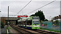
Tramlink
Tram arriving at Waddon Marsh.
In the background, the new Shurgard storage facility can be seen. This has replaced the one destroyed by fire, on New Year's Eve 2018, when 125 firefighters were involved in tackling the blaze. The official cause of the fire was recorded as undetermined, as the destroyed building was deemed unsafe and had to be demolished.
Image: © Peter Trimming
Taken: 17 Nov 2020
0.08 miles
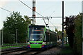
5
Tramlink
View towards Waddon Marsh, with the now disused gas holder to the left of picture.
Image: © Peter Trimming
Taken: 17 Nov 2020
0.08 miles
6
Tramline to Purley Way
As seen from Image
This is the tramline from Waddon Marsh Halt towards Therpia Lane Halt (and onwards to Wimbledon). It passes under the A23 Purley Way dual carriage way.
On the left, is a path leading from Ampere Way towards the Purley Way near Newman Road.
In the background is one of the Image
Image: © David Anstiss
Taken: 30 Oct 2011
0.08 miles
7
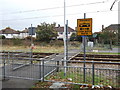
Tram crossing near Ampere Way
A footpath leads from Ampere Way towards Miller Road.
It crosses the Croydon Tramlink between Waddon Marsh Halt and Therpia Lane Halt.
Image: © David Anstiss
Taken: 30 Oct 2011
0.09 miles
9
Waddon Marsh tram stop
Car 2533 of Croydon Tramlink prepares to stop at Waddon Marsh on its way to New Addington via Central Croydon. Since its opening in June 2000, the tram system has become a very popular and well-used part of Croydon's transport network. This stop, serving major shops such as Sainsbury's, Mothercare, P C World and Jassop's, sees a tram every eight minutes in each direction.
Image: © Dr Neil Clifton
Taken: 3 Aug 2006
0.10 miles
10
Tramlink
Looking towards the Waddon Marsh tram stop.
Image: © Peter Trimming
Taken: 4 Nov 2022
0.10 miles