IMAGES TAKEN NEAR TO
Mitcham Road, CROYDON, CR0 3JE
Introduction
This page details the photographs taken nearby to Mitcham Road, CR0 3JE by members of the Geograph project.
The Geograph project started in 2005 with the aim of publishing, organising and preserving representative images for every square kilometre of Great Britain, Ireland and the Isle of Man.

There are currently over 7.5m images from over14,400 individuals and you can help contribute to the project by visiting https://www.geograph.org.uk
Image Map
Images are licensed for reuse under creativecommons.org/licenses/by-sa/2.0
Notes
- Clicking on the map will re-center to the selected point.
- The higher the marker number, the further away the image location is from the centre of the postcode.
Image Listing (49 Images Found)
Images are licensed for reuse under creativecommons.org/licenses/by-sa/2.0
Image
Details
Distance
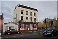
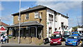
3
The New Inn Public House
Standing at the junction of Mitcham Road and Sumner Road, this is another pub which is closed.
Image: © Peter Trimming
Taken: 22 Mar 2009
0.03 miles
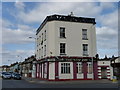
5
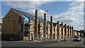
Houses in Mitcham Road
Standing at the junction of Sumner Road and Mitcham Road, these houses come complete with their own solar panels and wind turbine.
Image: © Peter Trimming
Taken: 22 Mar 2009
0.04 miles
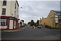
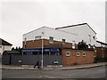
9
The Queen Victoria Public House
Stands on the busy Mitcham Road.
Image: © Peter Trimming
Taken: 22 Mar 2009
0.11 miles
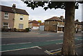
10
The Holy Redeemer St. Mark's Mission, Broad Green
Modern Church on the junction of Chapman Road (on the left) and Kingsley Road (on the right).
Image: © David Anstiss
Taken: 30 Oct 2011
0.12 miles