IMAGES TAKEN NEAR TO
Wentworth Road, CROYDON, CR0 3HX
Introduction
This page details the photographs taken nearby to Wentworth Road, CR0 3HX by members of the Geograph project.
The Geograph project started in 2005 with the aim of publishing, organising and preserving representative images for every square kilometre of Great Britain, Ireland and the Isle of Man.

There are currently over 7.5m images from over14,400 individuals and you can help contribute to the project by visiting https://www.geograph.org.uk
Image Map
Images are licensed for reuse under creativecommons.org/licenses/by-sa/2.0
Notes
- Clicking on the map will re-center to the selected point.
- The higher the marker number, the further away the image location is from the centre of the postcode.
Image Listing (60 Images Found)
Images are licensed for reuse under creativecommons.org/licenses/by-sa/2.0
Image
Details
Distance
1
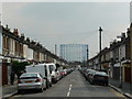
Wentworth Road, Croydon
Terraced housing on both sides of the road, and a view of the gasworks in the distance.
Image: © Peter Trimming
Taken: 20 Apr 2009
0.06 miles
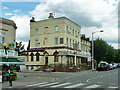
2

Canterbury Road
Two more casualties in the decline of the British pub. The Duke of York, at the junction with York Road, and The Mitre, at the junction with Sutherland Road.
Image: © Stephen Richards
Taken: Unknown
0.07 miles
3
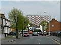
Canterbury Road, Croydon
Houses on the left, a combination of houses and light industry on the right. On the distant skyline is "Fusion", a residential refurbishment of what was previously the UK headquarters of Philips, the multi-national electrical company.
Image: © Peter Trimming
Taken: 20 Apr 2009
0.07 miles
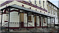
4
The Mitre Public House
Another of Croydon's pubs lost to closure.
Image: © Peter Trimming
Taken: 24 Mar 2009
0.07 miles
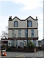
5
The Duke of York, still closed
One of the many closed pubs in this area, but looking in better shape than the norm.
Image: © Robin Webster
Taken: 29 Jun 2011
0.08 miles
6
The Duke of York Public House
Close-up of the front of the pub.
Image: © Peter Trimming
Taken: 24 Mar 2009
0.10 miles
7

Canterbury Road Recreation Ground
Canterbury Road Recreation ground was acquired by Croydon Council in 1931 to provide an open space for the densely populated area of Broad Green. The area had previously been the site of Waddon Marsh Farm which fronted Mitcham Road. A map drawn in 1910 shows the farm next to cricket and football pitches but these were later dug up to provide housing plots in Wentworth Road and Sunderland Road to the east.
Image: © Marathon
Taken: 11 Jul 2012
0.10 miles
8
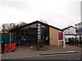
Broad Green Library
Modern building on Canterbury Road.
Image: © David Anstiss
Taken: 30 Oct 2011
0.12 miles
9

The Duke of York Public House
Standing directly opposite The Mitre, this impressive public house has also closed.
Image: © Peter Trimming
Taken: 24 Mar 2009
0.12 miles
10

Canterbury Road Recreation Ground
Canterbury Road Recreation ground was acquired by Croydon Council in 1931 to provide an open space for the densely populated area of Broad Green. The area had previously been the site of Waddon Marsh Farm which fronted Mitcham Road. A map drawn in 1910 shows the farm next to cricket and football pitches but these were later dug up to provide housing plots in Wentworth Road and Sunderland Road to the east. The gasholder in the distance is near Waddon Marsh Tramlink Stop.
Image: © Marathon
Taken: 11 Jul 2012
0.12 miles