IMAGES TAKEN NEAR TO
Laundry Close, CROYDON, CR0 2WH
Introduction
This page details the photographs taken nearby to Laundry Close, CR0 2WH by members of the Geograph project.
The Geograph project started in 2005 with the aim of publishing, organising and preserving representative images for every square kilometre of Great Britain, Ireland and the Isle of Man.

There are currently over 7.5m images from over14,400 individuals and you can help contribute to the project by visiting https://www.geograph.org.uk
Image Map
Images are licensed for reuse under creativecommons.org/licenses/by-sa/2.0
Notes
- Clicking on the map will re-center to the selected point.
- The higher the marker number, the further away the image location is from the centre of the postcode.
Image Listing (109 Images Found)
Images are licensed for reuse under creativecommons.org/licenses/by-sa/2.0
Image
Details
Distance
2
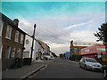
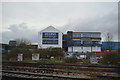
Gloucester Road, Croydon
The view towards the office blocks of Central Croydon.
Image: © Peter Trimming
Taken: 24 Apr 2009
0.03 miles
3
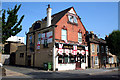
Croydon: The 'Drum and Monkey', Gloucester Road
Although the main signs (top left, and swinging sign on the front) have been blacked out, the 'Drum and Monkey' is still open, helped no doubt by interest just now in the World Cup.
Image: © Dr Neil Clifton
Taken: 14 Jun 2010
0.04 miles
4
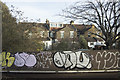
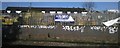
London Graffiti
This type of graffiti does nothing to enhance an area.
Image: © Malcolm Neal
Taken: 13 Feb 2019
0.04 miles
5
Trackside scenery, Croydon
Behind the fencing is what appears to be the depot of a skip hire firm: just visible is a tree festooned with rags and soft toys, a sort of Christo-meets-Kurt Schwitters artwork made, perhaps, of found objects from the skips hired out.
Image: © Christopher Hilton
Taken: 21 Mar 2014
0.06 miles
6
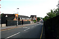
Croydon: Gloucester Road
Looking north from Windmill Bridge, where this unclassified road begins from a T-junction almost on top of the bridge, and runs to another junction with Northcote Road/ Selhurst Road, close to Selhurst Station. Gloucester Road is much-used by motorists wishing to avoid the complex junctions at Spurgeons Bridge, but traffic at its southern end is virtually at saturation point during the rush hour.
In the photograph, the 'Drum and Monkey' public house is seen part-way along on the left of the road.
Image: © Dr Neil Clifton
Taken: 14 Jun 2010
0.07 miles
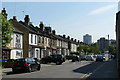
9
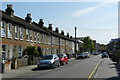
Milton Road, Croydon
Terraced housing dating from c1900. The view is towards Central Croydon, with tower blocks just visible in the distance.
Image: © Peter Trimming
Taken: 24 Apr 2009
0.08 miles
10
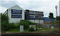
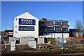
Access Self Storage
Beside the London to Brighton railway.
Image: © Russel Wills
Taken: 17 May 2014
0.08 miles