IMAGES TAKEN NEAR TO
Kemp Gardens, CROYDON, CR0 2TT
Introduction
This page details the photographs taken nearby to Kemp Gardens, CR0 2TT by members of the Geograph project.
The Geograph project started in 2005 with the aim of publishing, organising and preserving representative images for every square kilometre of Great Britain, Ireland and the Isle of Man.

There are currently over 7.5m images from over14,400 individuals and you can help contribute to the project by visiting https://www.geograph.org.uk
Image Map
Images are licensed for reuse under creativecommons.org/licenses/by-sa/2.0
Notes
- Clicking on the map will re-center to the selected point.
- The higher the marker number, the further away the image location is from the centre of the postcode.
Image Listing (109 Images Found)
Images are licensed for reuse under creativecommons.org/licenses/by-sa/2.0
Image
Details
Distance
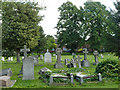
1
Lodge, Queen's Road Cemetery
At the main Queen's Road gate. There is also a pedestrian gate from Pawson's Road towards the far end of the cemetery.
Image: © Robin Webster
Taken: 29 Jun 2011
0.08 miles
2
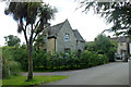
Cemetery lodge and gates, Queen's Road
The lodge was probably built in 1860 when the cemetery opened, and like the chapels, looks to be built of ragstone.
Image: © Stephen Richards
Taken: Unknown
0.10 miles
3
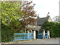
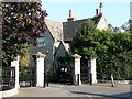
Entrance to Queen's Road Cemetery
This is the only entrance for vehicles. The gatehouse is now a privately owned house.
Image: © Peter Trimming
Taken: 20 Apr 2009
0.11 miles
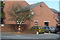
4

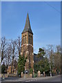
Holy Saviour Parish Church, Croydon
Holy Saviour Church was built as a daughter church of St James' in 1867 when the surrounding area was full of pig farms. This view looks past the base of the tower and along the south side adjacent to St Saviour's Road.
Image: © Marathon
Taken: 11 Jul 2012
0.11 miles
5
Rainbow Tree, Croydon
I've not seen one of these before, but it seems to be flourishing in its location, at the end of Prestwood Gardens.
Image: © Peter Trimming
Taken: 12 Oct 2009
0.11 miles
7
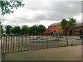
Play area off Windmill Grove, Croydon
Image: © Alex McGregor
Taken: 17 Jun 2011
0.11 miles
8

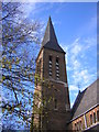
Holy Saviour Parish Church, Croydon
Holy Saviour Church was built as a daughter church of St James' in 1867 when the surrounding area was full of pig farms. This view looks to the west front from Lodge Road with the base of the tower on the right.
Image: © Marathon
Taken: 11 Jul 2012
0.12 miles