IMAGES TAKEN NEAR TO
Lodge Road, CROYDON, CR0 2PL
Introduction
This page details the photographs taken nearby to Lodge Road, CR0 2PL by members of the Geograph project.
The Geograph project started in 2005 with the aim of publishing, organising and preserving representative images for every square kilometre of Great Britain, Ireland and the Isle of Man.

There are currently over 7.5m images from over14,400 individuals and you can help contribute to the project by visiting https://www.geograph.org.uk
Image Map
Images are licensed for reuse under creativecommons.org/licenses/by-sa/2.0
Notes
- Clicking on the map will re-center to the selected point.
- The higher the marker number, the further away the image location is from the centre of the postcode.
Image Listing (78 Images Found)
Images are licensed for reuse under creativecommons.org/licenses/by-sa/2.0
Image
Details
Distance
1

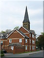
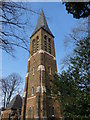
Holy Saviour Parish Church, Croydon
Holy Saviour Church was built as a daughter church of St James' in 1867 when the surrounding area was full of pig farms. This view looks past the base of the tower and along the south side adjacent to St Saviour's Road.
Image: © Marathon
Taken: 11 Jul 2012
0.05 miles
2

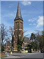
Holy Saviour Parish Church, Croydon
Holy Saviour Church was built as a daughter church of St James' in 1867 when the surrounding area was full of pig farms. This view looks to the west front from Lodge Road with the base of the tower on the right.
Image: © Marathon
Taken: 11 Jul 2012
0.05 miles
3
Flats in Campbell Road
On the junction of Campbell Road and Lodge Road, with the spire of St.Saviours Church visible in the background.
Image: © Peter Trimming
Taken: 20 Apr 2009
0.06 miles
4
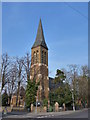
St Saviour, St Saviour Road
Large polychromatic Gothic church of 1867 by A.R. Mullins, with a powerful tower and spire. Grade II listed.
Image: © Stephen Richards
Taken: Unknown
0.06 miles
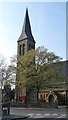
7
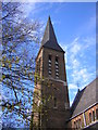
St.Saviours Church
Detail of the bell tower and spire.
Image: © Peter Trimming
Taken: 20 Mar 2009
0.08 miles
8
St.Saviours Church
Standing at the end of St.Saviours Road.
Image: © Peter Trimming
Taken: 20 Mar 2009
0.08 miles
9
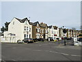
Lodge Road, Thornton Heath
Lodge Road is a residential road in Thornton Heath, in the suburbs of south London.
Image: © Malc McDonald
Taken: 18 Apr 2022
0.11 miles
10
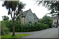
Lodge, Queen's Road Cemetery
At the main Queen's Road gate. There is also a pedestrian gate from Pawson's Road towards the far end of the cemetery.
Image: © Robin Webster
Taken: 29 Jun 2011
0.13 miles