IMAGES TAKEN NEAR TO
Turner Crescent, CROYDON, CR0 2NP
Introduction
This page details the photographs taken nearby to Turner Crescent, CR0 2NP by members of the Geograph project.
The Geograph project started in 2005 with the aim of publishing, organising and preserving representative images for every square kilometre of Great Britain, Ireland and the Isle of Man.

There are currently over 7.5m images from over14,400 individuals and you can help contribute to the project by visiting https://www.geograph.org.uk
Image Map
Images are licensed for reuse under creativecommons.org/licenses/by-sa/2.0
Notes
- Clicking on the map will re-center to the selected point.
- The higher the marker number, the further away the image location is from the centre of the postcode.
Image Listing (89 Images Found)
Images are licensed for reuse under creativecommons.org/licenses/by-sa/2.0
Image
Details
Distance
1
Flats, Harry Close
Facing Pawson's Road. The small wind turbine is unusual.
Image: © Robin Webster
Taken: 29 Jun 2011
0.07 miles
2
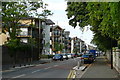
Pawson's Road, Croydon
The new housing, to the left of the road, is "affordable housing for key workers", and was built on the site of the former Queen's Hospital. Built as high density housing, with minimal provision for motor vehicles. Note the wind turbines on some of the houses.
To the right of the road is Queen's Road Cemetery. The "new" wall was built to replace the one destroyed, by falling trees, during the "Great Storm" of 1987.
Image: © Peter Trimming
Taken: 13 Jul 2009
0.08 miles
3
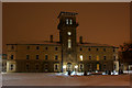
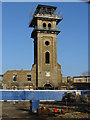
Croydon Workhouse - conversion 2
Originally built in 1865 as the Workhouse, and more recently known as Queen's Hospital, the tower is all that remains of the original structure.
Work is almost completed; converting the tower into luxury flats. Wings, in keeping with the original design, have been added. The development is known as "King's Tower". I wonder what the original occupants of the Workhouse would have thought.
Having seen an original photograph dating from 1865 (in Victorian Croydon Illustrated), I note that the original wings were more than twice the width of the re-build.
Image
Image
Image: © Peter Trimming
Taken: 30 Nov 2010
0.08 miles
4
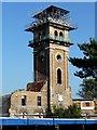
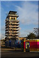
Queen's Hospital, Queen's Road
This was originally the Croydon Union Workhouse, designed in 1865-66 by John Berney. It was heavily damaged in the Second World War leaving just this Italianate tower (with a pyramid roof underneath the scaffolding) and a small section of the facade below. Grade II listed.
The area around it is being developed for housing and happily it looks as if the tower is being renovated. Or perhaps converted into a very tall and narrow bijou apartment.
Three months later it looked like this: Image
Image: © Stephen Richards
Taken: Unknown
0.09 miles
5
Croydon Workhouse
Originally built in 1865 as the Workhouse, and more recently known as Queen's Hospital, the tower is all that remains of the original structure.
The grounds have been used for housing development, and the tower is shortly to be restored.
Image: © Peter Trimming
Taken: 29 Jan 2009
0.09 miles
6
Croydon Workhouse - conversion
Originally built in 1865 as the Workhouse, and more recently known as Queen's Hospital, the tower is all that remains of the original structure.
Work has now started to convert the tower into luxury flats. As far as I can make out from the diagram, wings, in a contemporary design, will be added. The development will be known as "King's Tower". I wonder what the original occupants of the Workhouse would have thought.
Image: © Peter Trimming
Taken: 14 Dec 2009
0.10 miles
7
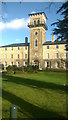
Former Croydon Union Workhouse
The workhouse here evolved, as many did, into a hospital (the workhouse infirmary was typically the last bit to remain functioning and at the abolition of the Poor Law in 1929 would pass into local authority control as a hospital). It was closed in the early years of the twenty-first century, the site being redeveloped for flats with only the main block, seen here, surviving.
Image: © Christopher Hilton
Taken: 5 Jan 2018
0.10 miles
8
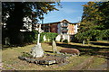
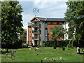
New View of old Grave
The houses in the background date from c2006, built on the site of the old Queen's Hospital. The grave in the foreground has been in place long enough to be affected by the ravages of time, and nature. The ivy-clad wall, in the centre of picture, was built to replace the one destroyed by the "Great Storm" of October 1987.
Image: © Peter Trimming
Taken: 8 Sep 2009
0.11 miles
9
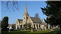
Twin Chapels in Queen's Road Cemetery
On a clear winter's afternoon, a view of the two Chapels from what I consider to be the best angle.
Image: © Peter Trimming
Taken: 29 Jan 2009
0.11 miles
10

Queen's Road Cemetery, Croydon
Looking towards the chapels, the right one of which is hidden by trees.
Image: © Peter Trimming
Taken: 8 Sep 2009
0.11 miles