IMAGES TAKEN NEAR TO
Berney Road, CROYDON, CR0 2JX
Introduction
This page details the photographs taken nearby to Berney Road, CR0 2JX by members of the Geograph project.
The Geograph project started in 2005 with the aim of publishing, organising and preserving representative images for every square kilometre of Great Britain, Ireland and the Isle of Man.

There are currently over 7.5m images from over14,400 individuals and you can help contribute to the project by visiting https://www.geograph.org.uk
Image Map
Images are licensed for reuse under creativecommons.org/licenses/by-sa/2.0
Notes
- Clicking on the map will re-center to the selected point.
- The higher the marker number, the further away the image location is from the centre of the postcode.
Image Listing (170 Images Found)
Images are licensed for reuse under creativecommons.org/licenses/by-sa/2.0
Image
Details
Distance
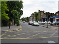
2
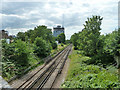
Railway towards West Croydon
The route of the original atmospheric London and Croydon Railway, laid more or less along the course of the earlier Croydon Canal from New Cross onwards. Here it is exactly on the route.
Image: © Robin Webster
Taken: 29 Jun 2011
0.02 miles
3
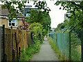
Former towpath, Croydon Canal
For a considerable distance this public footpath runs beside the railway that was built along the bed of the canal.
Image: © Robin Webster
Taken: 29 Jun 2011
0.03 miles
4
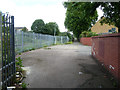
Wide section of path parallel to railway
There is a flagged area, vent pipes and a small cabinet. Presumably there is some sort of cistern under the path.
Image: © Robin Webster
Taken: 29 Jun 2011
0.07 miles
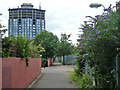
6

Sydenham Road, Croydon
Looking north, towards the bridge which crosses the railway line. The distant television transmitter, at Crystal Palace, can just be seen.
Image: © Peter Trimming
Taken: 22 Mar 2011
0.08 miles
7
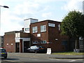
Polling Station at West Croydon Christian Centre
On this occasion in use for the European Election, but is also used for all other elections.
Image: © Peter Trimming
Taken: 4 Jun 2009
0.08 miles
8
Path parallel to railway
This follows the railway as far as St. James's Road. As the railway was laid on the bed of the Croydon Canal, it has been suggested this was once the towpath.
There is a wide section ahead at the end of Tavistock Grove with a flagged area, vent pipes and a small cabinet. Presumably there is some sort of cistern under the path.
Image: © Robin Webster
Taken: 29 Jun 2011
0.08 miles
9
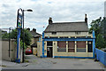
Bird in Hand, Sydenham Road
This looks a bit closed, but possibly a bit open (normally). Some time later it was demolished and the site redeveloped. The building, although old, was only identified as a pub on post-war maps, but there is an 1865 reference to a 'beer shop' here, which then was an off-licence for beer only.
Image: © Robin Webster
Taken: 29 Jun 2011
0.09 miles
10
Sydenham Road, Croydon
Looking north from the crossroads with St. James Road
Image: © Dr Neil Clifton
Taken: 8 Jun 2009
0.09 miles