IMAGES TAKEN NEAR TO
Strathmore Road, CROYDON, CR0 2JL
Introduction
This page details the photographs taken nearby to Strathmore Road, CR0 2JL by members of the Geograph project.
The Geograph project started in 2005 with the aim of publishing, organising and preserving representative images for every square kilometre of Great Britain, Ireland and the Isle of Man.

There are currently over 7.5m images from over14,400 individuals and you can help contribute to the project by visiting https://www.geograph.org.uk
Image Map
Images are licensed for reuse under creativecommons.org/licenses/by-sa/2.0
Notes
- Clicking on the map will re-center to the selected point.
- The higher the marker number, the further away the image location is from the centre of the postcode.
Image Listing (157 Images Found)
Images are licensed for reuse under creativecommons.org/licenses/by-sa/2.0
Image
Details
Distance
1
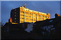
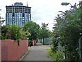
Sunlit Flats
After several days of wet, or heavily overcast, weather; a yellow object appeared, fleetingly, in the west! The result was a warm, evening, glow on a nearby block of flats, converted (c1996) from a redundant office block.
Image: © Peter Trimming
Taken: 4 Oct 2010
0.04 miles
3
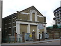
Electricity Sub-station, Croydon
Located right beside Spurgeon's Bridge.
Image: © Peter Trimming
Taken: 29 Mar 2009
0.05 miles
4
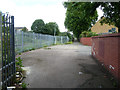
Wide section of path parallel to railway
There is a flagged area, vent pipes and a small cabinet. Presumably there is some sort of cistern under the path.
Image: © Robin Webster
Taken: 29 Jun 2011
0.05 miles
5
Path parallel to railway
This follows the railway as far as St. James's Road. As the railway was laid on the bed of the Croydon Canal, it has been suggested this was once the towpath.
There is a wide section ahead at the end of Tavistock Grove with a flagged area, vent pipes and a small cabinet. Presumably there is some sort of cistern under the path.
Image: © Robin Webster
Taken: 29 Jun 2011
0.05 miles
6
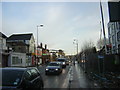
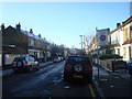
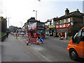
Whitehorse Road, Croydon, morning rush hour
A stream of traffic heads south into central Croydon.
Image: © Christopher Hilton
Taken: 28 Jan 2014
0.05 miles
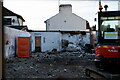
8
Croydon
Construction work at the junction of Union Road and Whitehorse Road.
Image: © Peter Trimming
Taken: 2 Aug 2022
0.05 miles
9
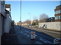
Croydon: Whitehorse Road
Looking south from the end of Union Road. The bus is on Route 157, which now operates Morden Station to Crystal Palace. This bus route was put on in 1960 to replace the 657, one of the last trolleybus routes in Croydon, which itself had, in the 1930's, replaced tram route 57, this having originated with the South Metropolitan company in pre-London Transport days. The present-day 157 is operated by Abellio, a subsidiary of Nederlandse Spoorwegen, and the buses carry the NS logo.
Image: © Dr Neil Clifton
Taken: 28 Mar 2011
0.06 miles
10
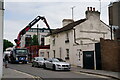
Formerly Brown Signs
From 1986 until 2021, Brown Signs was based in Whitehorse Road. The company relocated to Waddon and the building demolished to make way for a new building.
Image: © Peter Trimming
Taken: 27 Oct 2021
0.06 miles