IMAGES TAKEN NEAR TO
Gloucester Road, CROYDON, CR0 2DW
Introduction
This page details the photographs taken nearby to Gloucester Road, CR0 2DW by members of the Geograph project.
The Geograph project started in 2005 with the aim of publishing, organising and preserving representative images for every square kilometre of Great Britain, Ireland and the Isle of Man.

There are currently over 7.5m images from over14,400 individuals and you can help contribute to the project by visiting https://www.geograph.org.uk
Image Map
Images are licensed for reuse under creativecommons.org/licenses/by-sa/2.0
Notes
- Clicking on the map will re-center to the selected point.
- The higher the marker number, the further away the image location is from the centre of the postcode.
Image Listing (62 Images Found)
Images are licensed for reuse under creativecommons.org/licenses/by-sa/2.0
Image
Details
Distance
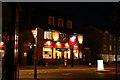
1
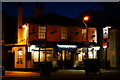
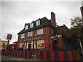
Two Brewers, Gloucester Road, Selhurst
I have spent many a happy hour, since 1975, in this public house, sampling the Shepherd Neame brews from Britain's oldest brewery (1698); indeed, my tankard lived here for a while, being produced as I walked through the door. Sadly, I have not visited in just over two years; I see that the pub is currently "to let", but I'm sure that the two facts are not connected.
Shepherd Neame's success story relates to their "Spitfire" ale, brewed to commemorate the 50th anniversary of the "Battle of Britain"; with some topical advertisements along the way. Some 20 years on, this beer goes from strength to strength, although the gravity has remained unchanged!
Image: © Peter Trimming
Taken: 23 Sep 2010
0.05 miles
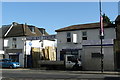
2
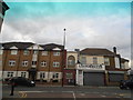
Selhurst Road at the junction of Gloucester Road, Selhurst
Image: © David Howard
Taken: 7 Oct 2012
0.06 miles
3

Owen Close, Selhurst
Owen Close is a modern housing development in Selhurst, near Croydon.
Image: © Malc McDonald
Taken: 14 Jul 2018
0.06 miles
4
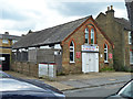
Former chapel, Selhurst Place
First appearing on 1890s maps as a 'Workmen's Chapel' later an institute, now a day nursery.
Image: © Robin Webster
Taken: 29 Jun 2011
0.07 miles
5
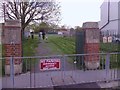
King George's Field, Croydon
The entrance to the King George's Field https://en.wikipedia.org/wiki/King_George%27s_Fields in Sydenham Road, Croydon
Image: © Roger W Haworth
Taken: 30 Apr 2012
0.08 miles
7
Selhurst Timber, Selhurst
About the only remaining specialist timber merchant in the area. I can think of three others which used to be within ten minutes' walk of this point.
Image: © Peter Trimming
Taken: 28 Aug 2009
0.08 miles
8
The Selhurst Arms (closed)
Later converted to a Co-op store.
Image: © Robin Webster
Taken: 29 Jun 2011
0.08 miles
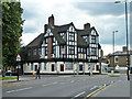
9
The Selhurst Arms, Selhurst Road, Selhurst
Located on the junction with Selhurst New Road. Selhurst is a common name in these parts, relating to the times when much of the area was densely wooded (the Great North Wood), as far as Norwood. I note that the pub is still "to let". In 35 years, I can count my visits, to this establishment, on the fingers of one hand.
Image: © Peter Trimming
Taken: 23 Sep 2010
0.09 miles
10
The White Horse, Northcote Road, Selhurst
This pub is named after the nearby Whitehorse Road, and is popular with supporters of Crystal Palace FC. In 35 years, I can count my visits, to this establishment, on the fingers of one hand.
Image: © Peter Trimming
Taken: 23 Sep 2010
0.10 miles