IMAGES TAKEN NEAR TO
Milton Road, CROYDON, CR0 2BG
Introduction
This page details the photographs taken nearby to Milton Road, CR0 2BG by members of the Geograph project.
The Geograph project started in 2005 with the aim of publishing, organising and preserving representative images for every square kilometre of Great Britain, Ireland and the Isle of Man.

There are currently over 7.5m images from over14,400 individuals and you can help contribute to the project by visiting https://www.geograph.org.uk
Image Map
Images are licensed for reuse under creativecommons.org/licenses/by-sa/2.0
Notes
- Clicking on the map will re-center to the selected point.
- The higher the marker number, the further away the image location is from the centre of the postcode.
Image Listing (141 Images Found)
Images are licensed for reuse under creativecommons.org/licenses/by-sa/2.0
Image
Details
Distance
1
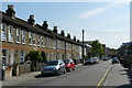
Milton Road, Croydon
Terraced housing dating from c1900. The view is towards Central Croydon, with tower blocks just visible in the distance.
Image: © Peter Trimming
Taken: 24 Apr 2009
0.04 miles
3
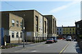
Albury Nursing Home
On the junction of Milton Road and St. James's Road. It still looks very new, but has been in use for a couple of years.
Image: © Peter Trimming
Taken: 24 Apr 2009
0.05 miles
4
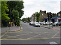
Croydon: Lansdowne Road
Looking south from its junction with St. James' Road. Lansdowne Road runs to a roundabout where it crosses Dingwall Road, whence it continues to a T-junction with Wellesley Road. Many years ago, buses on Route 197 ran along Lansdowne Road, but the road is not used by any bus route at present.
Image: © Dr Neil Clifton
Taken: 14 Jun 2010
0.06 miles
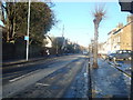
6
St James's Road at the junction of Sydenham Road
Image: © David Howard
Taken: 29 Jan 2012
0.08 miles
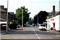
7
Sydenham Road, Croydon
Looking north from the crossroads with St. James Road
Image: © Dr Neil Clifton
Taken: 8 Jun 2009
0.08 miles
8
Croydon: St. James' Road
Looking west from Windmill Bridge. This is part of the A222. About half a mile along, there are complex junctions where the A212 crosses, after which St. James' Road continues until it meets London Road at Broad Green.
Image: © Dr Neil Clifton
Taken: 14 Jun 2010
0.08 miles
9
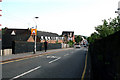
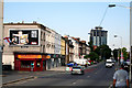
Croydon: Gloucester Road
Looking north from Windmill Bridge, where this unclassified road begins from a T-junction almost on top of the bridge, and runs to another junction with Northcote Road/ Selhurst Road, close to Selhurst Station. Gloucester Road is much-used by motorists wishing to avoid the complex junctions at Spurgeons Bridge, but traffic at its southern end is virtually at saturation point during the rush hour.
In the photograph, the 'Drum and Monkey' public house is seen part-way along on the left of the road.
Image: © Dr Neil Clifton
Taken: 14 Jun 2010
0.09 miles
10
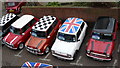
Mini-ature Parking Space
Junction of St.James's Road and Gloucester Road.
Image: © Peter Trimming
Taken: 19 Feb 2009
0.09 miles