IMAGES TAKEN NEAR TO
Wellesley Road, CROYDON, CR0 2AE
Introduction
This page details the photographs taken nearby to Wellesley Road, CR0 2AE by members of the Geograph project.
The Geograph project started in 2005 with the aim of publishing, organising and preserving representative images for every square kilometre of Great Britain, Ireland and the Isle of Man.

There are currently over 7.5m images from over14,400 individuals and you can help contribute to the project by visiting https://www.geograph.org.uk
Image Map
Images are licensed for reuse under creativecommons.org/licenses/by-sa/2.0
Notes
- Clicking on the map will re-center to the selected point.
- The higher the marker number, the further away the image location is from the centre of the postcode.
Image Listing (310 Images Found)
Images are licensed for reuse under creativecommons.org/licenses/by-sa/2.0
Image
Details
Distance
1
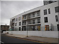
Lower level of office block on Newgate, Croydon
Image: © David Howard
Taken: 18 Oct 2015
0.06 miles
2
Woburn Road, Croydon
This is the end of Woburn Road, where it joins Tavistock Road. There may be a road name somewhere amongst the foliage! The bush to the left of picture is Fuchsia 'Riccartonii', which is extremely hardy and provides a good display each summer. In the background is the housing development which dominates the skyline in this part of Croydon.
Image: © Peter Trimming
Taken: 14 Jul 2009
0.08 miles
3
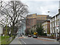
Street Scene, Wellesley Road, Croydon
The view towards Croydon.
The houses to the right of the photograph are Victorian; several are empty, boarded-up, and showing signs of likely demolition. However; I have read that these houses are now under a preservation order.
Image: © Peter Trimming
Taken: 29 Mar 2009
0.08 miles

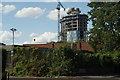
6
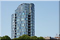
Croydon High-rise
A 20 storey development at Spurgeon's Bridge, and standing on the site of the Bridge Hotel.
The building took in excess of five years to complete, due to a variety of reasons. Whilst it appears to be in splendid isolation, there are several, taller, buildings nearby in the town centre.
Image: © Peter Trimming
Taken: 29 Jun 2018
0.09 miles
7

On a Call (2)
Seen in Tavistock Road, Croydon.
Image: © Peter Trimming
Taken: 2 Nov 2013
0.09 miles
8

On a Call (1)
Seen in Tavistock Road, Croydon.
Image: © Peter Trimming
Taken: 2 Nov 2013
0.09 miles
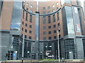
9
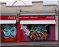
Croydon
Wellesley Road. For once, not open all hours; colourful shutters down on Christmas Day.
Image: © Peter Trimming
Taken: 25 Dec 2018
0.09 miles
10

After the Storm
A Croydon residential block, still under construction, had its crane struck by lightning early in the evening of 25th January. The Croydon Advertiser carried the following report:
"Police were called to reports of the broken crane at approximately 4.48pm this afternoon.
A London Ambulance Service spokeswoman said they had been called to reports of a crane snapping after it was struck by lightning.
Fire crews are still at the site, which is now known as the Island development, but a police spokesman said it is not thought anyone was hurt.
Despite this, there are currently 15 fire engines at the site and a police helicopter at the site.
Ambulances are also at the site on stand-by but have confirmed there are currently no patients to treat."
Photographed on the following afternoon.
Image: © Peter Trimming
Taken: 26 Jan 2014
0.09 miles