IMAGES TAKEN NEAR TO
Church Road, CROYDON, CR0 1SG
Introduction
This page details the photographs taken nearby to Church Road, CR0 1SG by members of the Geograph project.
The Geograph project started in 2005 with the aim of publishing, organising and preserving representative images for every square kilometre of Great Britain, Ireland and the Isle of Man.

There are currently over 7.5m images from over14,400 individuals and you can help contribute to the project by visiting https://www.geograph.org.uk
Image Map
Images are licensed for reuse under creativecommons.org/licenses/by-sa/2.0
Notes
- Clicking on the map will re-center to the selected point.
- The higher the marker number, the further away the image location is from the centre of the postcode.
Image Listing (768 Images Found)
Images are licensed for reuse under creativecommons.org/licenses/by-sa/2.0
Image
Details
Distance
1

Bus Art, 'Trammin''
At Charles Street, by Alice Cretney.
Image: © Oast House Archive
Taken: 2 Jan 2015
0.02 miles
2
Bus Art, 'Trammin''
At Charles Street, by Alice Cretney.
Also see Image
Image: © Oast House Archive
Taken: 2 Jan 2015
0.02 miles
3
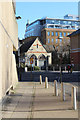
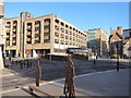
Charles Street
Looking towards Surrey Street pumping station, Grade II listed https://historicengland.org.uk/listing/the-list/list-entry/1079248
Image: © Oast House Archive
Taken: 2 Jan 2015
0.03 miles
4
Charles Street
Looking towards Surrey Street pumping station, Grade II listed https://historicengland.org.uk/listing/the-list/list-entry/1079248
Image: © Oast House Archive
Taken: 2 Jan 2015
0.03 miles
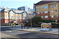
5
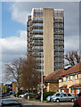
Croydon: Flats in Charles Street
These 1980s built apartments are a considerable improvement over what was on offer ten years earlier.
Image: © Dr Neil Clifton
Taken: 5 Feb 2010
0.04 miles
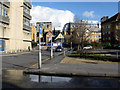
6
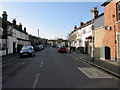
Croydon: Howley Road
From Church Road, looking west.
Image: © Dr Neil Clifton
Taken: 5 Feb 2010
0.05 miles
7
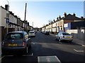
Croydon: Cranmer Road
From Church Road, looking west
Image: © Dr Neil Clifton
Taken: 5 Feb 2010
0.05 miles
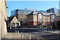
9
Ryland House, Charles Road (2)
Built for the Post Office and now British Telecom offices - at one point it housed the telephone exchange (and possibly it still does). In a quasi-Brutalist style with its extensive use of concrete. A plaque outside records its unveiling by Sir William Ryland, Chairman of the Post Office, 7th May 1974. Reputedly it is built on rafts to counteract the dampness of the underlying ground. The architects were Lister Drew & Associates in conjunction with the Property Services Agency.
Between the 1950s and the 1970s Croydon experienced a burst of commercial development unparalleled anywhere else in the country. The impetus was provided by the Croydon Corporation Act of 1956 which gave Croydon Council powers to develop land in the borough. A combination of improved roads, government incentives to relocate from, and Croydon's proximity to, central London, and lower rents attracted employers in their droves. By 1970 about six million square feet of office space had been provided in central Croydon. Development has continued since, but at a much slower rate. From a distance the skyline is impressive (the nearest this country comes to Manhattan), but the problem is that few of the buildings are of architectural merit.
Image: © Stephen Richards
Taken: Unknown
0.05 miles
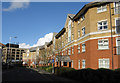
10
Croydon: Charles Street
From Church Road, looking east
Image: © Dr Neil Clifton
Taken: 5 Feb 2010
0.06 miles