IMAGES TAKEN NEAR TO
Tilford Avenue, CROYDON, CR0 0QS
Introduction
This page details the photographs taken nearby to Tilford Avenue, CR0 0QS by members of the Geograph project.
The Geograph project started in 2005 with the aim of publishing, organising and preserving representative images for every square kilometre of Great Britain, Ireland and the Isle of Man.

There are currently over 7.5m images from over14,400 individuals and you can help contribute to the project by visiting https://www.geograph.org.uk
Image Map
Images are licensed for reuse under creativecommons.org/licenses/by-sa/2.0
Notes
- Clicking on the map will re-center to the selected point.
- The higher the marker number, the further away the image location is from the centre of the postcode.
Image Listing (19 Images Found)
Images are licensed for reuse under creativecommons.org/licenses/by-sa/2.0
Image
Details
Distance
1
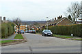
Tilford Avenue, New Addington
The high buildings of Canary Wharf are in the distance.
Image: © Robin Webster
Taken: 27 Feb 2011
0.01 miles
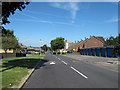
2
Housing on Castle Hill Avenue
Castle Hill Avenue is named after Castle Hill Farm, on whose land it was built.
Image: © Ian Capper
Taken: 1 Apr 2008
0.04 miles
3
Green on King Henry's Drive, New Addington
Image: © Robin Webster
Taken: 27 Feb 2011
0.08 miles
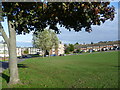
4
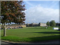
Looking across Walton Green, New Addington
New Addington is on a plateau but is not completely flat as can be seen here at Walton Green.
Image: © Marathon
Taken: 30 Oct 2013
0.08 miles
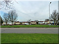
5
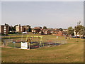
Recreational Ground near Walton Green
As seen from Castle Hill Avenue.
Image: © David Anstiss
Taken: 23 Oct 2011
0.09 miles
6
Walton Green, New Addington
New Addington is on a plateau but is not completely flat as can be seen here at Walton Green.
Image: © Marathon
Taken: 30 Oct 2013
0.10 miles
7
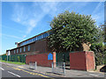
Wolsey School, New Addington
According to the sign outside, Wolsey school has nursery, infant and junior sections. The map shows that there is much more to the site than this building alongside Castle Hill Avenue.
Image: © Stephen Craven
Taken: 24 Jul 2011
0.15 miles
8
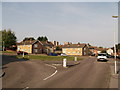
Roundabout on Frensham Drive
Frensham Drive leads from Castle Hill Avenue towards Headley Drive.
On the left is Dunsfold Way.
Image: © David Anstiss
Taken: 23 Oct 2011
0.20 miles
9
Castle Hill Avenue
One of the roads making up the large New Addington estate. The lamp standards are very much of their time (1950s).
Image: © Stephen Craven
Taken: 24 Jul 2011
0.20 miles
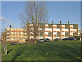
10

Tower blocks in New Addington
Most of the large New Addington estate is low-rise housing, but there are a few tower blocks like these two south of Castle Hill Road.
Image: © Stephen Craven
Taken: 24 Jul 2011
0.24 miles