IMAGES TAKEN NEAR TO
Aldrich Crescent, CROYDON, CR0 0NL
Introduction
This page details the photographs taken nearby to Aldrich Crescent, CR0 0NL by members of the Geograph project.
The Geograph project started in 2005 with the aim of publishing, organising and preserving representative images for every square kilometre of Great Britain, Ireland and the Isle of Man.

There are currently over 7.5m images from over14,400 individuals and you can help contribute to the project by visiting https://www.geograph.org.uk
Image Map
Images are licensed for reuse under creativecommons.org/licenses/by-sa/2.0
Notes
- Clicking on the map will re-center to the selected point.
- The higher the marker number, the further away the image location is from the centre of the postcode.
Image Listing (36 Images Found)
Images are licensed for reuse under creativecommons.org/licenses/by-sa/2.0
Image
Details
Distance
2

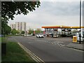
Lidl Supermarket, New Addington
Budget supermarket on the junction of King Henry's Drive (on the left) and Parkway (on the right).
This new (shop and 14 flats) development opened in the New Year of 2011. After years of planning objections.
It is on the site of a demolished pub, The Cunningham.
Image: © David Anstiss
Taken: 23 Oct 2011
0.12 miles
3
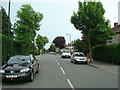
Parkway, New Addington
Parkway forms part of the main "spine" road through New Addington.
Image: © Malc McDonald
Taken: 2 May 2022
0.14 miles
6
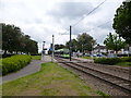
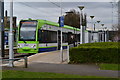
New Addington: King Henry's Drive tram stop
With car No 2549 about to leave for Croydon and Wimbledon
Image: © Dr Neil Clifton
Taken: 1 Jun 2012
0.15 miles
7
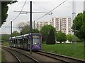
Tram in New Addington
A tram in New Addington, in south London's outer suburbs. The tram system opened in 2000. Prior to then, New Addington had relied entirely on buses to serve its public transport needs.
Image: © Malc McDonald
Taken: 2 May 2022
0.15 miles
8
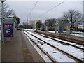
King Henry's Drive Tramlink Stop
Before Tramlink opened on 10th May 2000, there was no public transport to New Addington, other than buses. This is the view from the King Henry's Drive Tramlink Stop which is one stop away from the terminus and looks in the Croydon direction. Parkway is on the right. It had snowed three days before this photograph was taken and although much of the snow in the suburbs had melted, out here on the edge of Croydon it was still very much in evidence and bitterly cold.
Image: © Marathon
Taken: 8 Feb 2012
0.15 miles
9

King Henry's Drive Tramlink Stop
Before Tramlink opened on 10th May 2000, there was no public transport to New Addington, other than buses. This is the view of King Henry's Drive Tramlink Stop from Parkway. The terminus at New Addington is one stop away to the right. It had snowed three days before this photograph was taken and although much of the snow in the suburbs had melted, out here on the edge of Croydon it was still very much in evidence and bitterly cold.
Image: © Marathon
Taken: 8 Feb 2012
0.15 miles
10
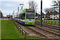
Tram pulling away from King Henry's Drive stop
Image: © David Martin
Taken: 3 Apr 2015
0.16 miles