IMAGES TAKEN NEAR TO
Cudham Drive, CROYDON, CR0 0LX
Introduction
This page details the photographs taken nearby to Cudham Drive, CR0 0LX by members of the Geograph project.
The Geograph project started in 2005 with the aim of publishing, organising and preserving representative images for every square kilometre of Great Britain, Ireland and the Isle of Man.

There are currently over 7.5m images from over14,400 individuals and you can help contribute to the project by visiting https://www.geograph.org.uk
Image Map
Images are licensed for reuse under creativecommons.org/licenses/by-sa/2.0
Notes
- Clicking on the map will re-center to the selected point.
- The higher the marker number, the further away the image location is from the centre of the postcode.
Image Listing (72 Images Found)
Images are licensed for reuse under creativecommons.org/licenses/by-sa/2.0
Image
Details
Distance
1

Trams: first day at New Addington
After a brief opening ceremony for invited guests, the first section of Croydon's new tram system opened for the public between West Croydon and New Addington. Here cars 2547 and 2537 are seen at the New Addington terminus on the first day.
Image: © Dr Neil Clifton
Taken: 10 May 2000
0.10 miles
2
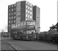
New in service at New Addington
Before the tram route to New Addington opened in 2000, public transport was entirely in the hands of buses. By far the most important of the bus routes was the 130 and its variants, linking New Addington with Croydon. Here, bus No M1167 is seen on its very first day in service on Route 130B. By its second day it had had to be taken out of service for graffiti to be removed.
Image: © Dr Neil Clifton
Taken: 23 Feb 1985
0.10 miles
3
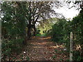
Footpath to Featherbed Lane
This track leads down from North Downs Road, New Addington. Towards a road beside Hutchinson's Bank Nature Reserve.
Image: © David Anstiss
Taken: 23 Oct 2011
0.11 miles
4
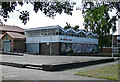
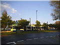
Library, New Addington
Opposite the shops on Central Parade. Built in 1964. New Addington was originally developed in the 1930s before being enlarged by Croydon Corporation as a quasi-new town. Pevsner describes it as a "classic example in the 1950s of prairie planning, or the pointless over-provision of open space, so that everything is too far apart." He describes the library as an effort to improve on amenities and "visual interest" (the zig-zag roof). A more recent extension is on the left.
Image: © Stephen Richards
Taken: Unknown
0.11 miles

6
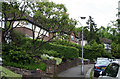
Addington: Farleigh Court Crescent
Very secluded residences off Featherbead Lane
Image: © Dr Neil Clifton
Taken: 4 Jun 2012
0.12 miles
7
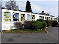
New Addington: Day centre for senior citizens
Near to the Health centre and the tram terminus.
Image: © Dr Neil Clifton
Taken: 23 Mar 2010
0.14 miles
9
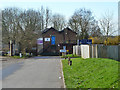
Kingfishers Association, New Addington
According to a Croydon Council document: "Kingfishers Association is the User Led Project for people with a mental health problem living in New Addington". The premises are rather older than the rest of New Addington, appearing on the 1868 map as Addington Lodge.
Image: © Robin Webster
Taken: 27 Feb 2011
0.14 miles
10
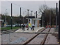
Tram at New Addington stop
This is the end of the line and is heading back to Croydon once the schedule allows.
Image: © David Howard
Taken: 20 Apr 2014
0.14 miles