IMAGES TAKEN NEAR TO
Fairchildes Avenue, CROYDON, CR0 0AN
Introduction
This page details the photographs taken nearby to Fairchildes Avenue, CR0 0AN by members of the Geograph project.
The Geograph project started in 2005 with the aim of publishing, organising and preserving representative images for every square kilometre of Great Britain, Ireland and the Isle of Man.

There are currently over 7.5m images from over14,400 individuals and you can help contribute to the project by visiting https://www.geograph.org.uk
Image Map
Images are licensed for reuse under creativecommons.org/licenses/by-sa/2.0
Notes
- Clicking on the map will re-center to the selected point.
- The higher the marker number, the further away the image location is from the centre of the postcode.
Image Listing (17 Images Found)
Images are licensed for reuse under creativecommons.org/licenses/by-sa/2.0
Image
Details
Distance
1
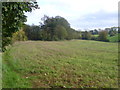
Countryside on the edge of New Addington
New Addington is a strange place, stuck out on a plateau and largely surrounded by Green Belt countryside. This is only a few metres from Fairchildes Avenue on the southern edge of New Addington but looking at this view you would never know such a built-up area was anywhere near. Gushybank Shaw is on the left here and Fairchildes Avenue is on the other side of it.
Image: © Marathon
Taken: 30 Oct 2013
0.04 miles
2
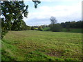
Countryside near New Addington
New Addington is a strange place, stuck out on a plateau and largely surrounded by Green Belt countryside. This is only a few metres from Fairchildes Avenue on the southern edge of New Addington but looking at this view you would never know such a built-up area was anywhere near.
Image: © Marathon
Taken: 30 Oct 2013
0.04 miles
3
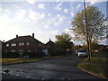
Kennelwood Crescent at the junction of Homestead Way
Image: © David Howard
Taken: 20 Apr 2014
0.04 miles
4
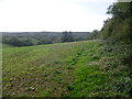
Countryside on the edge of New Addington
New Addington is a strange place, stuck out on a plateau and largely surrounded by Green Belt countryside. This is only a few metres from Fairchildes Avenue on the southern edge of New Addington but looking at this view you would never know such a built-up area was anywhere near.
Image: © Marathon
Taken: 30 Oct 2013
0.09 miles
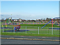
6
Milne Park Recreational Ground, New Addington
This large rectangular open-space area is between Milne Park East and Milne Park West.
Image: © David Anstiss
Taken: 9 Oct 2011
0.16 miles
7
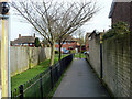
Passage from Thorpe Close to Homestead Way
The wood, frame and lamp on the extreme left are associated with new housing, one of two blocks, replacing two areas of lock-up garages of the sort nobody seems to use.
Image: © Robin Webster
Taken: 27 Feb 2011
0.17 miles
8
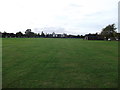
Looking across Milne Park
In 1930 an application was made for the use of a field at Addington as a private aerodrome. Croydon Corporation objected on environmental grounds but they were overruled by the Minister of Health. The Air Ministry sanctioned the use of the field in 1932. While the airfield operated it was used by the transport firm that owned it to train their pilots. An air pageant was held at the aerodrome in 1933, when aerobatics, parachute jumping, and wing walking were included on the list of entertainments. The field was not used during the Second World War and the company that owned it eventually moved to Gatwick to continue their business. Milne Park is all that now remains of the aerodrome as the adjacent land has been developed for housing and local amenities.
The land was acquired by the Council for housing but it was declared Green Belt Land and appropriated as public open space in 1963. It is now the largest open space in the southern half of New Addington.
Image: © Marathon
Taken: 30 Oct 2013
0.18 miles
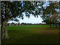
9
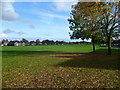
Milne Park, New Addington
In 1930 an application was made for the use of a field at Addington as a private aerodrome. Croydon Corporation objected on environmental grounds but they were overruled by the Minister of Health. The Air Ministry sanctioned the use of the field in 1932. While the airfield operated it was used by the transport firm that owned it to train their pilots. An air pageant was held at the aerodrome in 1933, when aerobatics, parachute jumping, and wing walking were included on the list of entertainments. The field was not used during the Second World War and the company that owned it eventually moved to Gatwick to continue their business. Milne Park is all that now remains of the aerodrome as the adjacent land has been developed for housing and local amenities.
The land was acquired by the Council for housing but it was declared Green Belt Land and appropriated as public open space in 1963. It is now the largest open space in the southern half of New Addington.
Image: © Marathon
Taken: 30 Oct 2013
0.18 miles
10
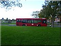
Bus terminus at Homestead Way, New Addington
The T31 bus terminates here at the southern edge of Milne Park.
Image: © Marathon
Taken: 30 Oct 2013
0.19 miles