IMAGES TAKEN NEAR TO
Morris Green, HALSTEAD, CO9 3LJ
Introduction
This page details the photographs taken nearby to Morris Green, CO9 3LJ by members of the Geograph project.
The Geograph project started in 2005 with the aim of publishing, organising and preserving representative images for every square kilometre of Great Britain, Ireland and the Isle of Man.

There are currently over 7.5m images from over14,400 individuals and you can help contribute to the project by visiting https://www.geograph.org.uk
Image Map
Images are licensed for reuse under creativecommons.org/licenses/by-sa/2.0
Notes
- Clicking on the map will re-center to the selected point.
- The higher the marker number, the further away the image location is from the centre of the postcode.
Image Listing (4 Images Found)
Images are licensed for reuse under creativecommons.org/licenses/by-sa/2.0
Image
Details
Distance
1
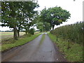
The driveway to Burnt House Farm
This view is from the very narrow lane which eventually reaches High Street Green. On this miserable October Saturday, it rained from beginning to end.
Image: © Marathon
Taken: 12 Oct 2019
0.16 miles
2
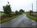
The lane to High Street Green
This is the narrow lane which eventually reaches High Street Green. The access road to Burnt House Farm is on the left. On this miserable October Saturday, it rained from beginning to end.
Image: © Marathon
Taken: 12 Oct 2019
0.18 miles
3
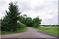
Burnt House Farm Drive
On the right hand side is the finger post for the path to Delvin End.
Image: © Glyn Baker
Taken: 30 May 2017
0.22 miles
4
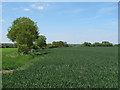
Footpath to Delvin End
Public footpath running north through arable land to Delvin End, in the parish of Sible Hedingham.
Image: © Roger Jones
Taken: 26 May 2013
0.23 miles