IMAGES TAKEN NEAR TO
Cripple Corner, HALSTEAD, CO9 2NX
Introduction
This page details the photographs taken nearby to Cripple Corner, CO9 2NX by members of the Geograph project.
The Geograph project started in 2005 with the aim of publishing, organising and preserving representative images for every square kilometre of Great Britain, Ireland and the Isle of Man.

There are currently over 7.5m images from over14,400 individuals and you can help contribute to the project by visiting https://www.geograph.org.uk
Image Map
Images are licensed for reuse under creativecommons.org/licenses/by-sa/2.0
Notes
- Clicking on the map will re-center to the selected point.
- The higher the marker number, the further away the image location is from the centre of the postcode.
Image Listing (7 Images Found)
Images are licensed for reuse under creativecommons.org/licenses/by-sa/2.0
Image
Details
Distance
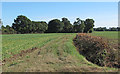
1

Cripple Corner road junction
Cripple Corner lies a short distance from the village of Pebmarsh.
Image: © Robert Edwards
Taken: 20 Sep 2006
0.05 miles
2
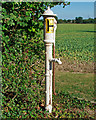
Water pump, near the Brambles, Twinstead
Appears to have a hydrant sign on it.
Image: © Roger Jones
Taken: 11 Sep 2016
0.07 miles
3
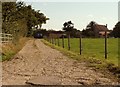
King's Farm, just east of Cripple Corner, Essex
Image: © Robert Edwards
Taken: 20 Sep 2006
0.20 miles
4
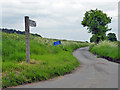
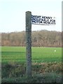
Lorkin's Lane
The fingerpost admits it is a way to Great Henny, but claims it is unsuitable for motor vehicles. The modern blue sign eases this to unsuitable for heavy goods vehicles.
Image: © Robin Webster
Taken: 21 May 2016
0.23 miles
5
Old Road Sign
Old road sign on minor road near to twinstead, Essex.
Image: © Keith Evans
Taken: 17 Jan 2017
0.23 miles
6
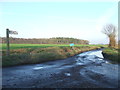
Minor Road Junction
Road junction near to twinstead, Essex.
Image: © Keith Evans
Taken: 17 Jan 2017
0.23 miles