IMAGES TAKEN NEAR TO
Old Ferry Road, COLCHESTER, CO7 9SW
Introduction
This page details the photographs taken nearby to Old Ferry Road, CO7 9SW by members of the Geograph project.
The Geograph project started in 2005 with the aim of publishing, organising and preserving representative images for every square kilometre of Great Britain, Ireland and the Isle of Man.

There are currently over 7.5m images from over14,400 individuals and you can help contribute to the project by visiting https://www.geograph.org.uk
Image Map
Images are licensed for reuse under creativecommons.org/licenses/by-sa/2.0
Notes
- Clicking on the map will re-center to the selected point.
- The higher the marker number, the further away the image location is from the centre of the postcode.
Image Listing (324 Images Found)
Images are licensed for reuse under creativecommons.org/licenses/by-sa/2.0
Image
Details
Distance
1
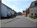
Spindrift Way, Wivenhoe
Looking North from its junction from Admirals Walk.
Image: © Hamish Griffin
Taken: 22 Jun 2014
0.04 miles
2
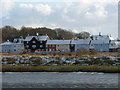
Wivenhoe Winter
Wivenhoe new homes in early 2006 light snow cover, viewed from Rowhedge Quay.
Image: © Nicholas Warner
Taken: 18 Jan 2006
0.05 miles
3
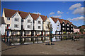
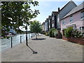
Modern housing at Wivenhoe dry dock
This shallow pond in front of the houses was once a dry dock, running at right angles to the quay at Wivenhoe. It has been filled in and a shallow pond created.
Image: © Bob Jones
Taken: 8 Oct 2008
0.06 miles
4
Old dry dock at Wivenhoe
Housing has been built on either side of the former dry dock at Wivenhoe. The old dock has been enclosed, creating a shallow pond which adds to the visual attraction of the area.
Image: © Bob Jones
Taken: 8 Oct 2008
0.06 miles
6
Looking west-northwest along Station Road
To the left of the station building is the engine shed, at present clad in scaffolding and polythene sheeting and undergoing restoration as described in these Colchester Borough Council’s planning applications: F/COL/03/0143 “change of use of the existing building to D1 (Assembly and Leisure). Restoration of the existing engine (goods) shed and rear extension” and LB/COL/03/0383 “Listed building. Restoration of the existing engine (goods) shed and rear extension”. It is grade II listed building dating from around 1866 http://www.britishlistedbuildings.co.uk/en-421988-goods-shed-to-south-west-south-of-wivenh
Image: © John Baker
Taken: 4 Apr 2014
0.07 miles
7
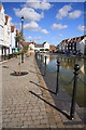
The West side of the Dry Dock
The street named after the Dry Dock is to the left of the water.
Image: © Hamish Griffin
Taken: 22 Jun 2014
0.07 miles
8
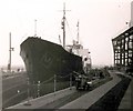
Ben Bates in dry dock
After completion the ship was moved to Wivenhoe Shipyard Co, Wivenhoe, Essex. Here the ship was inspected and repainted ready for handing over the owners.
The dry dock is now filled in and is an ornamental pond on a housing estate.
Image: © Peter Pearson
Taken: 13 May 1956
0.07 miles
9
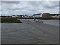
River Colne from Ferry Lane Fingringhoe
The new buildings across the River are in Wivenhoe
Image: © PAUL FARMER
Taken: 29 Aug 2010
0.07 miles
10
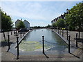
Dry Dock (from the North), Wivenhoe
See Image for an image from the South.
Image: © Hamish Griffin
Taken: 22 Jun 2014
0.07 miles