IMAGES TAKEN NEAR TO
Westlake Crescent, COLCHESTER, CO7 9RZ
Introduction
This page details the photographs taken nearby to Westlake Crescent, CO7 9RZ by members of the Geograph project.
The Geograph project started in 2005 with the aim of publishing, organising and preserving representative images for every square kilometre of Great Britain, Ireland and the Isle of Man.

There are currently over 7.5m images from over14,400 individuals and you can help contribute to the project by visiting https://www.geograph.org.uk
Image Map
Images are licensed for reuse under creativecommons.org/licenses/by-sa/2.0
Notes
- Clicking on the map will re-center to the selected point.
- The higher the marker number, the further away the image location is from the centre of the postcode.
Image Listing (12 Images Found)
Images are licensed for reuse under creativecommons.org/licenses/by-sa/2.0
Image
Details
Distance
1
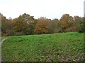
Woodland near Lower Lodge Farm
Lower Lodge Farm is now a housing estate, this woodland is between the estate and the River Colne.
Image: © Dave King
Taken: 2 Dec 2006
0.13 miles
2
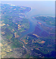
Wivenhoe and the Colne from the air
Wivenhoe is in the left foreground, with Rowhedge to the right. Point Clear bay is the built-up spit in the right distance, opposite Brightlingsea. Lee-Over-Sands can be seen at the top of the photo. Viewed from a Prague bound flight from Heathrow.
Image: © Thomas Nugent
Taken: 10 Apr 2011
0.13 miles
3
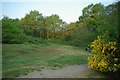
Wivenhoe Wood
Wivenhoe Wood http://www.wildessex.net/sites/Wivenhoe%20Wood.htm is in a Country Park and nature reserve managed by Colchester Council. Find out more about the reserve at http://www.wivenhoe.gov.uk/About_Wivenhoe/wivenhoe_wood.htm
Image: © Glyn Baker
Taken: 24 Apr 2011
0.14 miles
4
Maurice Britton Trail
Image http://www.wildessex.net/sites/Wivenhoe%20Wood.htm is in a Country Park and nature reserve managed by Colchester Council. The waymark commemorates a former Mayor of Wivenhoe by the Maurice Britton Trail. Find out more about the reserve at http://www.wivenhoe.gov.uk/About_Wivenhoe/wivenhoe_wood.htm
Image: © Glyn Baker
Taken: 24 Apr 2011
0.17 miles
5
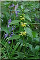
Yellow Archangel
Lamiastrum galeobdolon in Image
Image: © Glyn Baker
Taken: 24 Apr 2011
0.17 miles
6
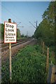
Towards Hythe
Looking towards Hythe Station from Image
Image: © Glyn Baker
Taken: 24 Apr 2011
0.18 miles
7
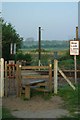
Crossing in Stile
Not much danger from trains this early on an Easter Sunday! Looking from the other side of the railway to Image The Green waymark is for the Maurice Britton Trail (a former mayor of Wivenhoe)
Image: © Glyn Baker
Taken: 24 Apr 2011
0.18 miles
8
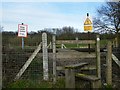
Crossing the railway with stile
At this point you can, with care, cross the railway from the Wivenhoe Trail to Wivenhoe.
Image: © Peter Rose
Taken: 14 Mar 2008
0.19 miles
9
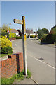
Heath Road, Wivenhoe
The public footpath leads off this suburban street between houses eventually to Wivenhoe Lodge. The sign might look suitably rustic but is virtually illegible.
Image: © Stephen McKay
Taken: 18 Apr 2018
0.20 miles
10
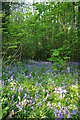
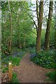
Bluebells in Wivenhoe Wood
Wivenhoe Wood http://www.wildessex.net/sites/Wivenhoe%20Wood.htm is in a Country Park and nature reserve managed by Colchester Council. Find out more about the reserve at http://www.wivenhoe.gov.uk/About_Wivenhoe/wivenhoe_wood.htm
Image: © Glyn Baker
Taken: 24 Apr 2011
0.20 miles