IMAGES TAKEN NEAR TO
Frating Road, COLCHESTER, CO7 8HU
Introduction
This page details the photographs taken nearby to Frating Road, CO7 8HU by members of the Geograph project.
The Geograph project started in 2005 with the aim of publishing, organising and preserving representative images for every square kilometre of Great Britain, Ireland and the Isle of Man.

There are currently over 7.5m images from over14,400 individuals and you can help contribute to the project by visiting https://www.geograph.org.uk
Image Map
Images are licensed for reuse under creativecommons.org/licenses/by-sa/2.0
Notes
- Clicking on the map will re-center to the selected point.
- The higher the marker number, the further away the image location is from the centre of the postcode.
Image Listing (8 Images Found)
Images are licensed for reuse under creativecommons.org/licenses/by-sa/2.0
Image
Details
Distance
1

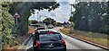
Thorrington Level Crossing
Looking from Church Road towards Frating Road.
Image: © Glyn Baker
Taken: 12 Aug 2023
0.10 miles

4

Thorrington level crossing, Station Road
Image: © PAUL FARMER
Taken: 16 Jan 2011
0.12 miles
5
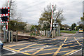
Thorrington: Level crossing
The electrified railway to Clacton crosses the B1029 at this point. Minor lanes also join the B1029 here, both north and south of the railway.
Image: © Dr Neil Clifton
Taken: 22 Apr 2015
0.12 miles
6

Thorrington level crossing
at the end of Station Road, Thorrington. The station has closed but trains between Colchester and Clacton/Walton still pass through so someone has to sit in the hut all day just to operate the crossing gates.
Image: © Roger W Haworth
Taken: 14 Feb 2006
0.13 miles
7
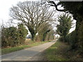
Country Lane, close to Thorrington
This road appears to have no name.
Image: © Robert Edwards
Taken: 10 Apr 2013
0.22 miles