IMAGES TAKEN NEAR TO
Wivenhoe Road, COLCHESTER, CO7 7BQ
Introduction
This page details the photographs taken nearby to Wivenhoe Road, CO7 7BQ by members of the Geograph project.
The Geograph project started in 2005 with the aim of publishing, organising and preserving representative images for every square kilometre of Great Britain, Ireland and the Isle of Man.

There are currently over 7.5m images from over14,400 individuals and you can help contribute to the project by visiting https://www.geograph.org.uk
Image Map
Images are licensed for reuse under creativecommons.org/licenses/by-sa/2.0
Notes
- Clicking on the map will re-center to the selected point.
- The higher the marker number, the further away the image location is from the centre of the postcode.
Image Listing (15 Images Found)
Images are licensed for reuse under creativecommons.org/licenses/by-sa/2.0
Image
Details
Distance
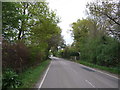
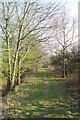
1

Wivenhoe Road, Crockleford Heath
Looking south.
Image: © JThomas
Taken: 24 Apr 2017
0.06 miles
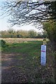
2
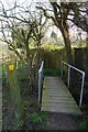
Footbridge & Diverted Path Notice
The yellow plaque is a Image
Image: © Glyn Baker
Taken: 29 Mar 2019
0.08 miles
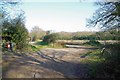
3
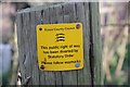
Footpath Diverted Sign
This sign on Image tended to confirm my suspicions that the "private" signs around
Image were not strictly legitimate as there were none of these official signs in evidence there.
Image: © Glyn Baker
Taken: 29 Mar 2019
0.08 miles
5
Footpath 158_47
The path is 775m long from Bromley Rd to beyond the Image
Image: © Glyn Baker
Taken: 29 Mar 2019
0.11 miles
6
County Council Notices
The notices on this waymark post propose the creation of a Image
Image: © Glyn Baker
Taken: 29 Mar 2019
0.12 miles
7
New Byway
I have deep reservations about the motivation behind the Image upgrading these paths (158_34 & 158_36) from public footpaths to restricted byway status. If the council wanted to allow cycling an upgrade to bridleway would be fine, I suspect this maybe to give access to a development site, (cynical.... me?!). Image crosses from left to right.
Image: © Glyn Baker
Taken: 29 Mar 2019
0.13 miles
8
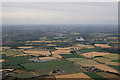
A120 and Crockleford Heath
Crockleford Heath is in the centre of the photo. The A120 is a dominant feature and Ardleigh reservoir can be seen.
Image: © terry joyce
Taken: 6 Jul 2010
0.16 miles
9
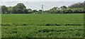
Crockleford Heath, Essex
Farmland in the vicinity of Crockleford Heath.
Image: © Rebecca A Wills
Taken: 30 Apr 2022
0.16 miles