IMAGES TAKEN NEAR TO
Promenade Way, COLCHESTER, CO7 0HJ
Introduction
This page details the photographs taken nearby to Promenade Way, CO7 0HJ by members of the Geograph project.
The Geograph project started in 2005 with the aim of publishing, organising and preserving representative images for every square kilometre of Great Britain, Ireland and the Isle of Man.

There are currently over 7.5m images from over14,400 individuals and you can help contribute to the project by visiting https://www.geograph.org.uk
Image Map
Images are licensed for reuse under creativecommons.org/licenses/by-sa/2.0
Notes
- Clicking on the map will re-center to the selected point.
- The higher the marker number, the further away the image location is from the centre of the postcode.
Image Listing (58 Images Found)
Images are licensed for reuse under creativecommons.org/licenses/by-sa/2.0
Image
Details
Distance
1
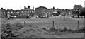
Site of Brightlingsea Station
View NW: completely obliterated site of terminus - buffer stops were to the right, of ex-Great Eastern line from Wivenhoe. The branch had been closed from 2/ to 12/53, after the Great Floods of 31/1/53, but was restored, only to be closed completely on 15/6/64.
Image: © Ben Brooksbank
Taken: 30 May 1983
0.05 miles
2
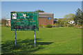
Brightlingsea Community Centre
The community centre is an undistinguished building dating from 1975 but it does incorporate the Liberty Hall which has a capacity for 250 people. Even so, the rather scruffy sign could do with a spruce up. This was the site of Brightlingsea station at the end of a branch from Wivenhoe. The railway was closed in 1964 and the building demolished in 1969. This amateur film from 1963 captures the atmosphere of the line in its dying days: https://player.bfi.org.uk/free/film/watch-river-ride-1963-online
Image: © Stephen McKay
Taken: 18 Apr 2018
0.05 miles
3
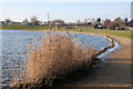
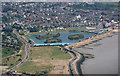
Boating Lake, Brightlingsea
Dug out of the salt marsh in the 1930s, the lake is about a metre deep. It is topped up with sea water at high tide from sluices direct from the beach. The lack of fresh water has led swans and some ducks to walk their chicks away from the lake in search of other fresh water ponds.
Image: © Bob Jones
Taken: 29 Jan 2009
0.06 miles
4
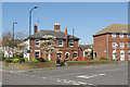
The Railway Tavern, Brightlingsea
Brightlingsea has a Railway Tavern on Station Road but sadly no longer has any trains. Nevertheless, the pub has a good reputation for the beer it sells including those brewed in a microbrewery on the premises. The local Campaign for Real Ale branch describes their Crab and Winkle mild as a 'legend'.
Image: © Stephen McKay
Taken: 18 Apr 2018
0.07 miles
5

Lower Park Road, Brightlingsea
The Railway Tavern opposite uses the National Rail logo on its sign but the station, which was across the road, closed in 1964 and there is no trace of it now.
Image: © Stephen McKay
Taken: 18 Apr 2018
0.08 miles
6

Beach hut padlock
Detail of an orange padlock on a yellow beach hut, adjacent to the boating lake, Brightlingsea.
Image: © Bob Jones
Taken: 29 Jan 2009
0.08 miles
7
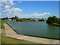
The Boating Lake
Brightlingsea attraction
Image: © John Myers
Taken: 10 Aug 2014
0.09 miles
8
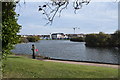
Boating Lake, Brightlingsea
With the marina beyond.
Image: © Trevor Harris
Taken: 4 Nov 2018
0.10 miles
10
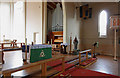
St James, Brightlingsea, Essex - Interior
Image: © John Salmon
Taken: 19 Aug 2010
0.11 miles