IMAGES TAKEN NEAR TO
Horkesley Road, COLCHESTER, CO6 4JN
Introduction
This page details the photographs taken nearby to Horkesley Road, CO6 4JN by members of the Geograph project.
The Geograph project started in 2005 with the aim of publishing, organising and preserving representative images for every square kilometre of Great Britain, Ireland and the Isle of Man.

There are currently over 7.5m images from over14,400 individuals and you can help contribute to the project by visiting https://www.geograph.org.uk
Image Map
Images are licensed for reuse under creativecommons.org/licenses/by-sa/2.0
Notes
- Clicking on the map will re-center to the selected point.
- The higher the marker number, the further away the image location is from the centre of the postcode.
Image Listing (170 Images Found)
Images are licensed for reuse under creativecommons.org/licenses/by-sa/2.0
Image
Details
Distance
2
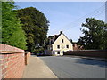
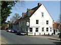
The Anchor public house in Nayland
Looking toward the Anchor from across the bridge. The Anchor sits on the bank of the Stour river.
Image: © Nina Metson
Taken: 20 Sep 2008
0.02 miles
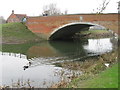
3
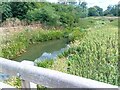
The River Stour from Nayland Bridge
Close to the Anchor Inn, the garden of which can be seen on the left of the photograph.
Image: © Roger Jones
Taken: 28 Sep 2014
0.03 miles
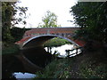
5

Old Boundary Marker
Bridge Marker set in south bridge parapet of Nayland Bridge, River Stour. NAYLAND WITH WISSINGTON parish. A / 1775 in relief. Nayland Bridge is also called Bell Bridge and Anchor Bridge and was built in 1775 to replace a wooden one given by nearby clothier in Nayland named John Abell, who died in 1524. The bridge is Grade II Listed https://historicengland.org.uk/listing/the-list/list-entry/1222738.
Milestone Society National ID: SU_NAYL02br
Image: © M Bardell
Taken: 12 Nov 2019
0.03 miles
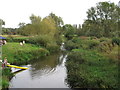
6
River Stour, Nayland
A small branch of the River Stour to the south of Nayland village, taken from the footbridge that crosses it.
Image: © Pebble
Taken: 27 Aug 2022
0.03 miles
7
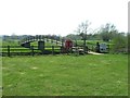
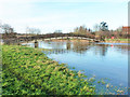
Footbridge
Footbridge over the River Stour at Nayland, Suffolk.
Image: © Keith Evans
Taken: 29 Mar 2012
0.04 miles
8
The Anchor Inn
The Anchor Inn public house at Nayland, Suffolk
Image: © Keith Evans
Taken: 29 Mar 2012
0.04 miles
9
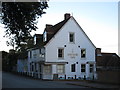
The Anchor Inn, Nayland
Dates from the nineteenth century http://www.britishlistedbuildings.co.uk/en-278411-the-anchor-public-house-nayland-with-wis#.WCOjBySq-Tw
Image: © Jonathan Thacker
Taken: 7 Nov 2016
0.04 miles
10
Footbridge over Stour flood relief channel, Nayland
The channel bypasses a loop of the river. The main channel is over to the right of the central pier and was flowing extremely fast. All the rest is shallower and only comes into action at high levels. The near bank was just overtopped behind the camera and the river was flooding into fields.
Image: © Robin Webster
Taken: 13 Jan 2016
0.05 miles