IMAGES TAKEN NEAR TO
Colchester Road, COLCHESTER, CO6 3JU
Introduction
This page details the photographs taken nearby to Colchester Road, CO6 3JU by members of the Geograph project.
The Geograph project started in 2005 with the aim of publishing, organising and preserving representative images for every square kilometre of Great Britain, Ireland and the Isle of Man.

There are currently over 7.5m images from over14,400 individuals and you can help contribute to the project by visiting https://www.geograph.org.uk
Image Map
Images are licensed for reuse under creativecommons.org/licenses/by-sa/2.0
Notes
- Clicking on the map will re-center to the selected point.
- The higher the marker number, the further away the image location is from the centre of the postcode.
Image Listing (13 Images Found)
Images are licensed for reuse under creativecommons.org/licenses/by-sa/2.0
Image
Details
Distance
1
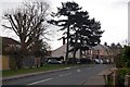
The Essex Way 116
The Essex Way follows roads through West Bergholt. Here it turns left ahead into Armoury Road.
Image: © Trevor Harris
Taken: 13 Mar 2011
0.02 miles
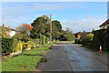
2
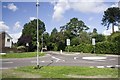
Road into West Bergholt from the north side of the village
Image: © Matthew Barker
Taken: 28 Aug 2006
0.04 miles
4
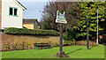
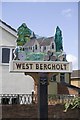
Village Sign and Beacon, West Bergholt
Located at the junction of Colchester Road and Chapel Road.
The beacon claims to be No. 987 of 4,200 worldwide.
The village sign depicts the old church of St. Mary's to be found about half a mile out of the village, to the north west. Now in the care of the Churches Conservation Trust.
Image: © Chris Heaton
Taken: 15 Oct 2020
0.05 miles
5
Armoury Road, West Bergholt
Adopted by the Essex Way long distance footpath as it heads north east out of West Bergholt
Image: © Chris Heaton
Taken: 15 Oct 2020
0.06 miles
7
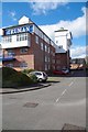
The Former Daniell's Brewery
The Daniell family once owned the Castle & West Burgholt Breweries (seen here). In 1866 the businesses merged to form Daniell and Son Breweries. The Castle Brewery in the centre of Colchester closed in 1892. In 1958 London Brewer Truman Hanbury & Buxton bought out Daniell's and its 150 tied houses. The following year Daniell's ceased brewing and the tied estate was rebranded.
The maltings (demolished 1989) and brewery were used as a distribution depot. In 1971 Truman was bought out by Grand Metropolitan who then bought Watney Mann and promptly merged the two. Truman ceased brewing in 1989.
Britain's oldest name in Brewing "Truman" rose phoenix like from the ashes in 2010 when the brand was bought from Scottish & Newcastle by two entrepreneurs.
Image: © Glyn Baker
Taken: 7 Mar 2019
0.16 miles
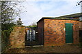
8
West Bergholt Allotments
Established in 1832 after an area of common land on Bergholt Heath (now almost all built upon) was bequeathed to the village "for the benefit of the poor". The land was used as allotments for the poor of the village.
Image: © Matthew Barker
Taken: 28 Aug 2006
0.16 miles
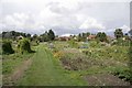
9
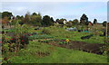
West Bergholt Allotments
Passed by on the Essex Way, while it adopts the pavement on New Church Road which runs along one side of these allotments.
Image: © Chris Heaton
Taken: 15 Oct 2020
0.19 miles
10
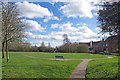
Play Area on the Memorial Way
The path is a memorial to the workers at Image who were killed in WW1
Image: © Glyn Baker
Taken: 7 Mar 2019
0.20 miles