IMAGES TAKEN NEAR TO
Chapel Road, COLCHESTER, CO6 3HL
Introduction
This page details the photographs taken nearby to Chapel Road, CO6 3HL by members of the Geograph project.
The Geograph project started in 2005 with the aim of publishing, organising and preserving representative images for every square kilometre of Great Britain, Ireland and the Isle of Man.

There are currently over 7.5m images from over14,400 individuals and you can help contribute to the project by visiting https://www.geograph.org.uk
Image Map
Images are licensed for reuse under creativecommons.org/licenses/by-sa/2.0
Notes
- Clicking on the map will re-center to the selected point.
- The higher the marker number, the further away the image location is from the centre of the postcode.
Image Listing (14 Images Found)
Images are licensed for reuse under creativecommons.org/licenses/by-sa/2.0
Image
Details
Distance
1
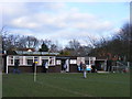
West Bergholt FC Clubhouse
Behind the Memorial Hall on the Lexden Road.
Image: © Stuart Shepherd
Taken: 7 Feb 2009
0.13 miles
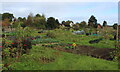
2
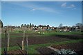
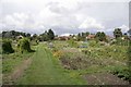
West Bergholt Allotments
In wouldn't be surprised if there will be soon be pressure to turn this area into desirable semi's (I hope I am wrong).
Image: © Glyn Baker
Taken: 9 Mar 2019
0.14 miles
3

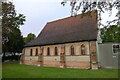
St Mary the Virgin Church, West Bergholt, Essex
Image: © Peter Stack
Taken: 13 Aug 2009
0.15 miles
4
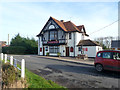
The Queens Head, West Bergholt
Across the road from a duck pond, hence the railings.
Image: © Robin Webster
Taken: 13 Jan 2016
0.15 miles
5
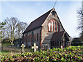
'New' church, West Bergholt
Consecrated in 1904, replacing the very much older church which still stands, but inconveniently some way out from the village centre. Both are St. Mary's.
Image: © Robin Webster
Taken: 13 Jan 2016
0.15 miles
6
Church of St Mary the Virgin, West Bergholt
On New Church Road. As the village began to grow further to the east, this new church supplanted the original (11th century) St Mary's 'Old Church' at West Bergholt Hall Image which closed in 1904 (but is still consecrated). (Ref Wikipedia articles)
Image: © Tim Heaton
Taken: 15 Oct 2020
0.15 miles
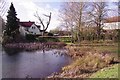
7
Duck pond, West Bergholt
Across the road from the Queens Head, off to the right.
Image: © Robin Webster
Taken: 13 Jan 2016
0.15 miles
8
West Bergholt Allotments
Passed by on the Essex Way, while it adopts the pavement on New Church Road which runs along one side of these allotments.
Image: © Chris Heaton
Taken: 15 Oct 2020
0.16 miles
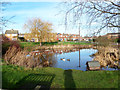
9
Duck Pond by Lexden Rd
West Bergholt is well supplied with duck ponds!
Image: © Glyn Baker
Taken: 9 Mar 2019
0.18 miles
10
West Bergholt Allotments
Established in 1832 after an area of common land on Bergholt Heath (now almost all built upon) was bequeathed to the village "for the benefit of the poor". The land was used as allotments for the poor of the village.
Image: © Matthew Barker
Taken: 28 Aug 2006
0.18 miles